Villa Soriano geodata
Villa Soriano (Soriano) is a populated place; located in Uruguay in America/Montevideo (GMT-3) time zone. With population of 1,195 people, there are 110 cities with bigger population in this country. Compared to other cities in Uruguay, 64.8% of cities are located further ↓South; 99.2% of cities are located further →East and 98.4% of cities have higher elevation than Villa Soriano. Note1


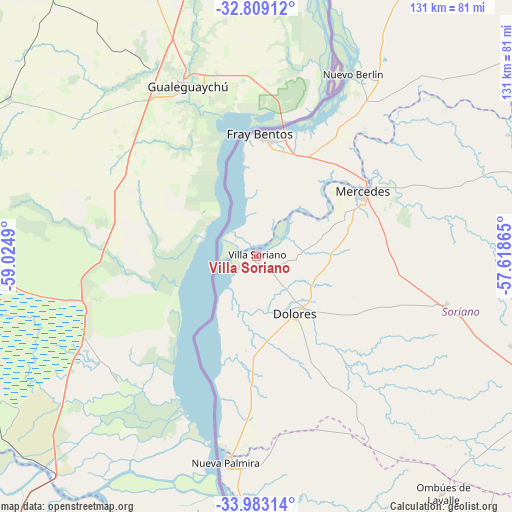
Villa Soriano GPS coordinates[2]
33° 23' 53.196" South, 58° 19' 18.372" West
| Map corner | latitude | longitude |
|---|---|---|
| Upper-left | -32.80912°, | -59.0249° |
| Center: | -33.39811°, | -58.32177° |
| Lower-right: | -33.98314°, | -57.61865° |
| Map W x H: | 130.5×130.5 km | = 81.1×81.1mi |
| max Lat: | -30.25966° ⇑35.2% North |
| Villa Soriano: | -33.39811° |
| min Lat: | ⇓64.8% South -34.94747° |
| min Long | Villa Soriano | max Long |
| -58.41176° | -58.32177° | -53.38583° |
| W 0.8%⇐ | ⇒99.2% E |
Elevation
Elevation of Villa Soriano is 5 m = 16 ft, and this is 65.6 m = 215 ft below average elevation for this country.
| Max E: |
294 m = 965 ft | 98.4% |
| Avg. | 70.6 m = 232 ft | |
| Villa Soriano | 5 m = 16 ft | |
Min E: |
2 m = 7 ft | 1.6% |
See also: Uruguay elevation on elevation.city.
Geographical zone
Villa Soriano is located in South temperate zone (between Tropic of Capricorn and the Antarctic Circle). Distance of this Southern Tropic circle is 1107.6 km =688.2 mi to North.| Distance of | km | miles | from Villa Soriano |
|---|---|---|---|
| Equator | 3713.5 | 2307.5 | to North |
| Tropic Capricorn | 1107.6 | 688.2 | to North |
| Antarctic Circle | 3687.7 | 2291.4 | to South |
| South Pole | 6293.5 | 3910.6 | to South |


Nearby cities:
15 places around Villa Soriano: (largest is in red/bold)
• Cardona
102.6 km =63.8 mi,  120°
120°
• Carmelo
67 km =41.6 mi,  177°
177°
• Dolores
17.6 km =10.9 mi,  146°
146°
• Florencio Sánchez
102.9 km =63.9 mi, 121°
• Fray Bentos
31.3 km =19.4 mi,  1°
1°
• José Enrique Rodó
80.4 km =50 mi,  114°
114°
• Mercedes
31.5 km =19.6 mi,  59°
59°
• Nueva Palmira
53.2 km =33.1 mi,  189°
189°
• Nuevo Berlín
52.6 km =32.7 mi,  27°
27°
• Ombúes de Lavalle
76.5 km =47.5 mi,  141°
141°
• Palmitas
49.8 km =30.9 mi,  104°
104°
• San Javier
83.4 km =51.8 mi,  12°
12°
• Santa Catalina
88.7 km =55.1 mi, 119°
• Tarariras
116.3 km =72.3 mi, 146°
• Young
101.2 km =62.9 mi,  39°
39°
Sources, notices
• [Note1] Compared only with cities in Uruguay existing in our database
• [Src1] Map data: © OpenStreetMap contributors (CC-BY-SA)
• [Src2] Other city data from geonames.org with taken over terms of usage.
• [Src3] Geographical zone / Annual Mean Temperature by Robert A. Rohde @ Wikipedia
