Fray Bentos geodata
Fray Bentos (Río Negro) is a seat of a first-order administrative division; located in Uruguay in America/Montevideo (GMT-3) time zone. With population of 23,279 people, there are 19 cities with bigger population in this country. Compared to other cities in Uruguay, 72.1% of cities are located further ↓South; 98.4% of cities are located further →East and 82.8% of cities have higher elevation than Fray Bentos. Note1


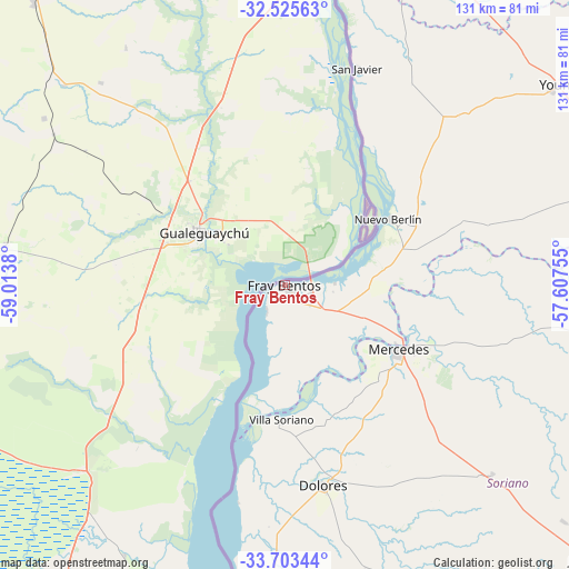
Fray Bentos GPS coordinates[2]
33° 6' 59.436" South, 58° 18' 38.412" West
| Map corner | latitude | longitude |
|---|---|---|
| Upper-left | -32.52563°, | -59.0138° |
| Center: | -33.11651°, | -58.31067° |
| Lower-right: | -33.70344°, | -57.60755° |
| Map W x H: | 131×131 km | = 81.4×81.4mi |
| max Lat: | -30.25966° ⇑27.9% North |
| Fray Bentos: | -33.11651° |
| min Lat: | ⇓72.1% South -34.94747° |
| min Long | Fray Bentos | max Long |
| -58.41176° | -58.31067° | -53.38583° |
| W 1.6%⇐ | ⇒98.4% E |
Elevation
Elevation of Fray Bentos is 17 m = 56 ft, and this is 53.6 m = 176 ft below average elevation for this country.
| Max E: |
294 m = 965 ft | 82.8% |
| Avg. | 70.6 m = 232 ft | |
| Fray Bentos | 17 m = 56 ft | |
Min E: |
2 m = 7 ft | 17.2% |
See also: Uruguay elevation on elevation.city.
Geographical zone
Fray Bentos is located in South temperate zone (between Tropic of Capricorn and the Antarctic Circle). Distance of this Southern Tropic circle is 1076.3 km =668.8 mi to North.| Distance of | km | miles | from Fray Bentos |
|---|---|---|---|
| Equator | 3682.2 | 2288 | to North |
| Tropic Capricorn | 1076.3 | 668.8 | to North |
| Antarctic Circle | 3719 | 2310.9 | to South |
| South Pole | 6324.9 | 3930.1 | to South |


Nearby cities:
15 places around Fray Bentos: (largest is in red/bold)
• Carmelo
98.3 km =61.1 mi,  178°
178°
• Dolores
46.8 km =29.1 mi,  169°
169°
• Estación Porvenir
93.3 km =58 mi,  27°
27°
• José Enrique Rodó
96.9 km =60.2 mi,  131°
131°
• Mercedes
30.1 km =18.7 mi,  120°
120°
• Nueva Palmira
84.3 km =52.4 mi,  186°
186°
• Nuevo Berlín
28 km =17.4 mi,  57°
57°
• Ombúes de Lavalle
102.5 km =63.7 mi,  153°
153°
• Palmitas
64.3 km =40 mi, 132°
• Paysandú
91.5 km =56.9 mi,  13°
13°
• Piedras Coloradas
105.6 km =65.6 mi,  38°
38°
• San Félix
87.9 km =54.6 mi, 12°
• San Javier
52.8 km =32.8 mi,  18°
18°
• Villa Soriano
31.3 km =19.4 mi, 181°
• Young
79 km =49.1 mi,  53°
53°
In other languages:
- In Spanish: Villa de Fray Bentos, Villa Fray Bentos, Villa Independencia
- In Russian: Фрай-Бентос
- In Chinese: 弗賴本托斯
Sources, notices
• [Note1] Compared only with cities in Uruguay existing in our database
• [Src1] Map data: © OpenStreetMap contributors (CC-BY-SA)
• [Src2] Other city data from geonames.org with taken over terms of usage.
• [Src3] Geographical zone / Annual Mean Temperature by Robert A. Rohde @ Wikipedia
