Mercedes geodata
Mercedes (Soriano) is a seat of a first-order administrative division; located in Uruguay in America/Montevideo (GMT-3) time zone. With population of 42,359 people, there are 8 cities with bigger population in this country. Compared to other cities in Uruguay, 69.7% of cities are located further ↓South; 92.6% of cities are located further →East and 71.3% of cities have higher elevation than Mercedes. Note1


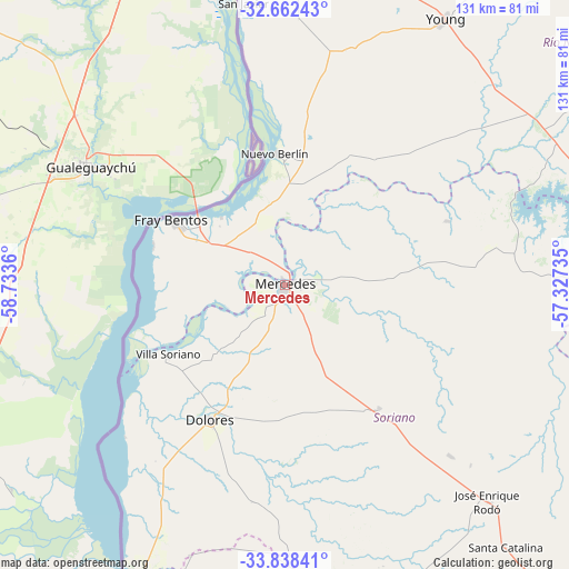
Mercedes GPS coordinates[2]
33° 15' 8.64" South, 58° 1' 49.692" West
| Map corner | latitude | longitude |
|---|---|---|
| Upper-left | -32.66243°, | -58.7336° |
| Center: | -33.2524°, | -58.03047° |
| Lower-right: | -33.83841°, | -57.32735° |
| Map W x H: | 130.8×130.8 km | = 81.3×81.3mi |
| max Lat: | -30.25966° ⇑30.3% North |
| Mercedes: | -33.2524° |
| min Lat: | ⇓69.7% South -34.94747° |
| min Long | Mercedes | max Long |
| -58.41176° | -58.03047° | -53.38583° |
| W 7.4%⇐ | ⇒92.6% E |
Elevation
Elevation of Mercedes is 29 m = 95 ft, and this is 41.6 m = 136 ft below average elevation for this country.
| Max E: |
294 m = 965 ft | 71.3% |
| Avg. | 70.6 m = 232 ft | |
| Mercedes | 29 m = 95 ft | |
Min E: |
2 m = 7 ft | 28.7% |
See also: Mercedes elevation on elevation.city.
Geographical zone
Mercedes is located in South temperate zone (between Tropic of Capricorn and the Antarctic Circle). Distance of this Southern Tropic circle is 1091.4 km =678.2 mi to North.| Distance of | km | miles | from Mercedes |
|---|---|---|---|
| Equator | 3697.3 | 2297.4 | to North |
| Tropic Capricorn | 1091.4 | 678.2 | to North |
| Antarctic Circle | 3703.9 | 2301.5 | to South |
| South Pole | 6309.7 | 3920.7 | to South |


Nearby cities:
15 places around Mercedes: (largest is in red/bold)
• Cardona
92 km =57.2 mi,  138°
138°
• Carmelo
86.4 km =53.7 mi,  195°
195°
• Dolores
35.4 km =22 mi,  209°
209°
• Estación Porvenir
99.4 km =61.8 mi,  9°
9°
• Florencio Sánchez
92.5 km =57.5 mi, 138°
• Fray Bentos
30.1 km =18.7 mi,  300°
300°
• José Enrique Rodó
67.6 km =42 mi, 136°
• Nueva Palmira
77.3 km =48 mi, 207°
• Nuevo Berlín
30.4 km =18.9 mi,  355°
355°
• Ombúes de Lavalle
78.9 km =49 mi,  164°
164°
• Palmitas
35.5 km =22.1 mi, 143°
• San Javier
66 km =41 mi,  351°
351°
• Santa Catalina
78.2 km =48.6 mi, 139°
• Villa Soriano
31.5 km =19.6 mi,  239°
239°
• Young
72.2 km =44.9 mi,  31°
31°
Sources, notices
• [Note1] Compared only with cities in Uruguay existing in our database
• [Src1] Map data: © OpenStreetMap contributors (CC-BY-SA)
• [Src2] Other city data from geonames.org with taken over terms of usage.
• [Src3] Geographical zone / Annual Mean Temperature by Robert A. Rohde @ Wikipedia
