Santa Rosa geodata
Santa Rosa (Canelones) is a populated place; located in Uruguay in America/Montevideo (GMT-3) time zone. With population of 3,711 people, there are 64 cities with bigger population in this country. Compared to other cities in Uruguay, 71.3% of cities are located further ↑North; 54.9% of cities are located further ←West and 55.7% of cities have lower elevation than Santa Rosa. Note1


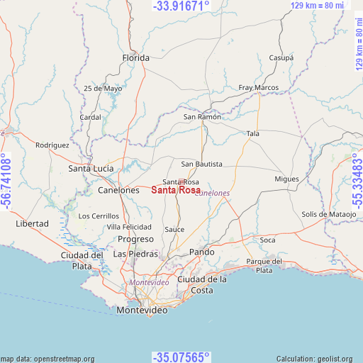
Santa Rosa GPS coordinates[2]
34° 29' 53.484" South, 56° 2' 16.62" West
| Map corner | latitude | longitude |
|---|---|---|
| Upper-left | -33.91671°, | -56.74108° |
| Center: | -34.49819°, | -56.03795° |
| Lower-right: | -35.07565°, | -55.33483° |
| Map W x H: | 128.9×128.9 km | = 80.1×80.1mi |
| max Lat: | -30.25966° ⇑71.3% North |
| Santa Rosa: | -34.49819° |
| min Lat: | ⇓28.7% South -34.94747° |
| min Long | Santa Rosa | max Long |
| -58.41176° | -56.03795° | -53.38583° |
| W 54.9%⇐ | ⇒45.1% E |
Elevation
Elevation of Santa Rosa is 58 m = 190 ft, and this is 12.6 m = 41 ft below average elevation for this country.
| Max E: |
294 m = 965 ft | 44.3% |
| Avg. | 70.6 m = 232 ft | |
| Santa Rosa | 58 m = 190 ft | |
Min E: |
2 m = 7 ft | 55.7% |
See also: Uruguay elevation on elevation.city.
Geographical zone
Santa Rosa is located in South temperate zone (between Tropic of Capricorn and the Antarctic Circle). Distance of this Southern Tropic circle is 1229.9 km =764.2 mi to North.| Distance of | km | miles | from Santa Rosa |
|---|---|---|---|
| Equator | 3835.8 | 2383.5 | to North |
| Tropic Capricorn | 1229.9 | 764.2 | to North |
| Antarctic Circle | 3565.3 | 2215.4 | to South |
| South Pole | 6171.2 | 3834.6 | to South |


Nearby cities:
15 places around Santa Rosa: (largest is in red/bold)
• Barros Blancos
28.5 km =17.7 mi,  173°
173°
• Canelones
22.1 km =13.7 mi,  262°
262°
• Empalme Olmos
25.8 km =16 mi,  149°
149°
• Joaquín Suárez
26.3 km =16.3 mi,  179°
179°
• Juanicó
22.4 km =13.9 mi,  241°
241°
• Las Piedras
30.7 km =19.1 mi,  212°
212°
• Pando
25.4 km =15.8 mi,  163°
163°
• Progreso
25 km =15.5 mi,  221°
221°
• San Antonio
6.5 km =4 mi,  323°
323°
• San Bautista
9.7 km =6 mi,  48°
48°
• San Jacinto
16.1 km =10 mi,  108°
108°
• San Ramón
24.2 km =15 mi,  18°
18°
• Sauce
17.3 km =10.7 mi,  188°
188°
• Tala
30.5 km =19 mi,  55°
55°
• Toledo
27.2 km =16.9 mi, 191°
Sources, notices
• [Note1] Compared only with cities in Uruguay existing in our database
• [Src1] Map data: © OpenStreetMap contributors (CC-BY-SA)
• [Src2] Other city data from geonames.org with taken over terms of usage.
• [Src3] Geographical zone / Annual Mean Temperature by Robert A. Rohde @ Wikipedia
