Maldonado geodata
Maldonado is a seat of a first-order administrative division; located in Uruguay in America/Montevideo (GMT-3) time zone. With population of 55,478 people, there are 5 cities with bigger population in this country. Compared to other cities in Uruguay, 98.4% of cities are located further ↑North; 81.1% of cities are located further ←West and 70.5% of cities have higher elevation than Maldonado. Note1


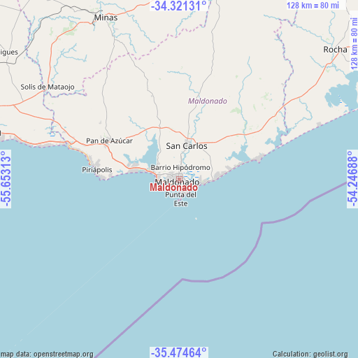
Maldonado GPS coordinates[2]
34° 54' 0" South, 54° 57' 0" West
| Map corner | latitude | longitude |
|---|---|---|
| Upper-left | -34.32131°, | -55.65313° |
| Center: | -34.9°, | -54.95° |
| Lower-right: | -35.47464°, | -54.24688° |
| Map W x H: | 128.2×128.2 km | = 79.7×79.7mi |
| max Lat: | -30.25966° ⇑98.4% North |
| Maldonado: | -34.9° |
| min Lat: | ⇓1.6% South -34.94747° |
| min Long | Maldonado | max Long |
| -58.41176° | -54.95° | -53.38583° |
| W 81.1%⇐ | ⇒18.9% E |
Elevation
Elevation of Maldonado is 30 m = 98 ft, and this is 40.6 m = 133 ft below average elevation for this country.
| Max E: |
294 m = 965 ft | 70.5% |
| Avg. | 70.6 m = 232 ft | |
| Maldonado | 30 m = 98 ft | |
Min E: |
2 m = 7 ft | 29.5% |
See also: Maldonado elevation on elevation.city.
Geographical zone
Maldonado is located in South temperate zone (between Tropic of Capricorn and the Antarctic Circle). Distance of this Southern Tropic circle is 1274.6 km =792 mi to North.| Distance of | km | miles | from Maldonado |
|---|---|---|---|
| Equator | 3880.5 | 2411.2 | to North |
| Tropic Capricorn | 1274.6 | 792 | to North |
| Antarctic Circle | 3520.7 | 2187.7 | to South |
| South Pole | 6126.5 | 3806.8 | to South |


Nearby cities:
15 places around Maldonado: (largest is in red/bold)
• Aiguá
79.3 km =49.3 mi,  12°
12°
• Atlántida
75.1 km =46.7 mi,  280°
280°
• La Floresta
68.7 km =42.7 mi, 283°
• La Paloma
76.4 km =47.5 mi,  69°
69°
• Las Toscas
72.4 km =45 mi, 284°
• Migues
77.1 km =47.9 mi,  306°
306°
• Minas
63.9 km =39.7 mi,  335°
335°
• Montes
71.9 km =44.7 mi, 308°
• Pan de Azúcar
29.4 km =18.3 mi,  297°
297°
• Piriápolis
29.9 km =18.6 mi, 277°
• Punta del Este
5.5 km =3.4 mi,  164°
164°
• Rocha
73 km =45.4 mi,  50°
50°
• San Carlos
12.4 km =7.7 mi, 13°
• Soca
72.7 km =45.2 mi,  289°
289°
• Solís de Mataojo
57.9 km =36 mi, 305°
Sources, notices
• [Note1] Compared only with cities in Uruguay existing in our database
• [Src1] Map data: © OpenStreetMap contributors (CC-BY-SA)
• [Src2] Other city data from geonames.org with taken over terms of usage.
• [Src3] Geographical zone / Annual Mean Temperature by Robert A. Rohde @ Wikipedia
