San Carlos geodata
San Carlos (Maldonado) is a populated place; located in Uruguay in America/Montevideo (GMT-3) time zone. With population of 24,938 people, there are 17 cities with bigger population in this country. Compared to other cities in Uruguay, 93.4% of cities are located further ↑North; 83.6% of cities are located further ←West and 72.1% of cities have higher elevation than San Carlos. Note1


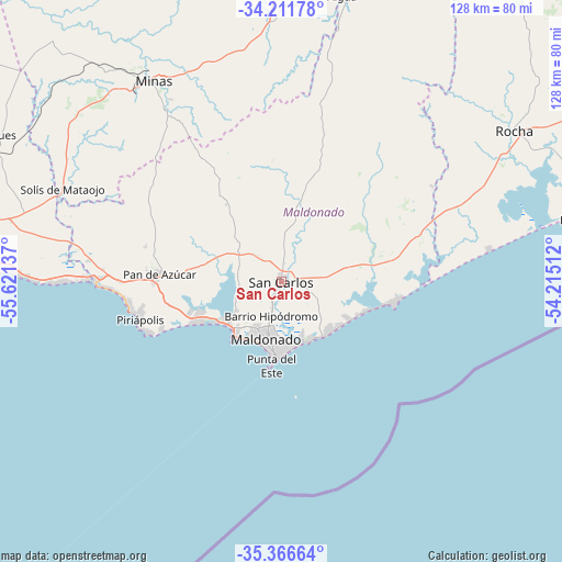
San Carlos GPS coordinates[2]
34° 47' 28.428" South, 54° 55' 5.664" West
| Map corner | latitude | longitude |
|---|---|---|
| Upper-left | -34.21178°, | -55.62137° |
| Center: | -34.79123°, | -54.91824° |
| Lower-right: | -35.36664°, | -54.21512° |
| Map W x H: | 128.4×128.4 km | = 79.8×79.8mi |
| max Lat: | -30.25966° ⇑93.4% North |
| San Carlos: | -34.79123° |
| min Lat: | ⇓6.6% South -34.94747° |
| min Long | San Carlos | max Long |
| -58.41176° | -54.91824° | -53.38583° |
| W 83.6%⇐ | ⇒16.4% E |
Elevation
Elevation of San Carlos is 28 m = 92 ft, and this is 42.6 m = 140 ft below average elevation for this country.
| Max E: |
294 m = 965 ft | 72.1% |
| Avg. | 70.6 m = 232 ft | |
| San Carlos | 28 m = 92 ft | |
Min E: |
2 m = 7 ft | 27.9% |
See also: Uruguay elevation on elevation.city.
Geographical zone
San Carlos is located in South temperate zone (between Tropic of Capricorn and the Antarctic Circle). Distance of this Southern Tropic circle is 1262.5 km =784.5 mi to North.| Distance of | km | miles | from San Carlos |
|---|---|---|---|
| Equator | 3868.4 | 2403.7 | to North |
| Tropic Capricorn | 1262.5 | 784.5 | to North |
| Antarctic Circle | 3532.8 | 2195.2 | to South |
| South Pole | 6138.6 | 3814.3 | to South |


Nearby cities:
15 places around San Carlos: (largest is in red/bold)
• Aiguá
66.8 km =41.5 mi,  12°
12°
• Atlántida
76.8 km =47.7 mi,  271°
271°
• La Floresta
69.8 km =43.4 mi, 273°
• La Paloma
70.3 km =43.7 mi,  78°
78°
• Las Toscas
73.2 km =45.5 mi,  275°
275°
• Maldonado
12.4 km =7.7 mi,  193°
193°
• Migues
73.2 km =45.5 mi,  297°
297°
• Minas
54.7 km =34 mi,  327°
327°
• Montes
67.6 km =42 mi, 299°
• Pan de Azúcar
29 km =18 mi, 272°
• Piriápolis
33.5 km =20.8 mi,  256°
256°
• Punta del Este
17.4 km =10.8 mi,  184°
184°
• Rocha
63.5 km =39.5 mi,  57°
57°
• Soca
72.6 km =45.1 mi, 279°
• Solís de Mataojo
54.6 km =33.9 mi,  292°
292°
Sources, notices
• [Note1] Compared only with cities in Uruguay existing in our database
• [Src1] Map data: © OpenStreetMap contributors (CC-BY-SA)
• [Src2] Other city data from geonames.org with taken over terms of usage.
• [Src3] Geographical zone / Annual Mean Temperature by Robert A. Rohde @ Wikipedia
