San Ramón geodata
San Ramón (Canelones) is a populated place; located in Uruguay in America/Montevideo (GMT-3) time zone. With population of 7,008 people, there are 47 cities with bigger population in this country. Compared to other cities in Uruguay, 57.4% of cities are located further ↑North; 62.3% of cities are located further ←West and 58.2% of cities have higher elevation than San Ramón. Note1


San Ramón GPS coordinates[2]
34° 17' 29.58" South, 55° 57' 20.556" West
| Map corner | latitude | longitude |
|---|---|---|
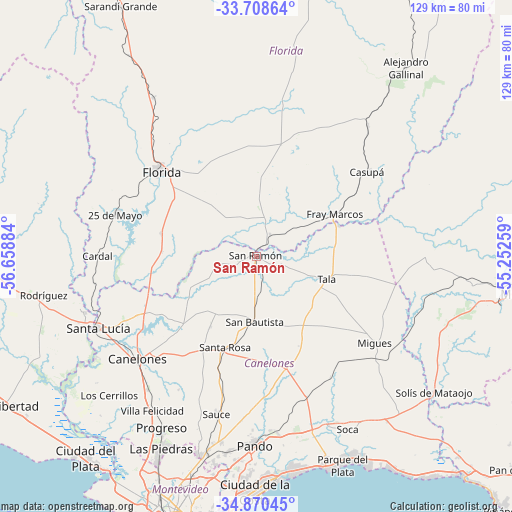
| Upper-left | -33.70864°, | -56.65884° |
| Center: | -34.29155°, | -55.95571° |
| Lower-right: | -34.87045°, | -55.25259° |
| Map W x H: | 129.2×129.2 km | = 80.3×80.3mi |
| max Lat: | -30.25966° ⇑57.4% North |
| San Ramón: | -34.29155° |
| min Lat: | ⇓42.6% South -34.94747° |
| min Long | San Ramón | max Long |
| -58.41176° | -55.95571° | -53.38583° |
| W 62.3%⇐ | ⇒37.7% E |
Elevation
Elevation of San Ramón is 44 m = 144 ft, and this is 26.6 m = 87 ft below average elevation for this country.
| Max E: |
294 m = 965 ft | 58.2% |
| Avg. | 70.6 m = 232 ft | |
| San Ramón | 44 m = 144 ft | |
Min E: |
2 m = 7 ft | 41.8% |
See also: Uruguay elevation on elevation.city.
Geographical zone
San Ramón is located in South temperate zone (between Tropic of Capricorn and the Antarctic Circle). Distance of this Southern Tropic circle is 1206.9 km =749.9 mi to North.| Distance of | km | miles | from San Ramón |
|---|---|---|---|
| Equator | 3812.9 | 2369.2 | to North |
| Tropic Capricorn | 1206.9 | 749.9 | to North |
| Antarctic Circle | 3588.3 | 2229.7 | to South |
| South Pole | 6194.2 | 3848.9 | to South |


Nearby cities:
15 places around San Ramón: (largest is in red/bold)
• 25 de Agosto
43.1 km =26.8 mi,  251°
251°
• 25 de Mayo
37.1 km =23.1 mi,  287°
287°
• Canelones
39.2 km =24.4 mi,  228°
228°
• Cardal
39.8 km =24.7 mi,  270°
270°
• Casupá
35.4 km =22 mi,  53°
53°
• Florida
32.2 km =20 mi,  312°
312°
• Juanicó
43.4 km =27 mi,  219°
219°
• Migues
37.1 km =23.1 mi,  125°
125°
• Montes
42.5 km =26.4 mi,  121°
121°
• San Antonio
21.1 km =13.1 mi,  212°
212°
• San Bautista
16.5 km =10.3 mi,  180°
180°
• San Jacinto
29.2 km =18.1 mi,  164°
164°
• Santa Rosa
24.2 km =15 mi,  198°
198°
• Sauce
41.3 km =25.7 mi,  193°
193°
• Tala
18.6 km =11.6 mi,  108°
108°
Sources, notices
• [Note1] Compared only with cities in Uruguay existing in our database
• [Src1] Map data: © OpenStreetMap contributors (CC-BY-SA)
• [Src2] Other city data from geonames.org with taken over terms of usage.
• [Src3] Geographical zone / Annual Mean Temperature by Robert A. Rohde @ Wikipedia
