Paysandú geodata
Paysandú is a seat of a first-order administrative division; located in Uruguay in America/Montevideo (GMT-3) time zone. With population of 73,249 people, there are 2 cities with bigger population in this country. Compared to other cities in Uruguay, 86.1% of cities are located further ↓South; 94.3% of cities are located further →East and 54.1% of cities have higher elevation than Paysandú. Note1


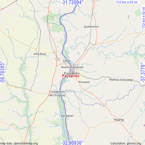
Paysandú GPS coordinates[2]
32° 19' 1.56" South, 58° 4' 50.592" West
| Map corner | latitude | longitude |
|---|---|---|
| Upper-left | -31.72094°, | -58.78385° |
| Center: | -32.3171°, | -58.08072° |
| Lower-right: | -32.90936°, | -57.3776° |
| Map W x H: | 132.1×132.1 km | = 82.1×82.1mi |
| max Lat: | -30.25966° ⇑13.9% North |
| Paysandú: | -32.3171° |
| min Lat: | ⇓86.1% South -34.94747° |
| min Long | Paysandú | max Long |
| -58.41176° | -58.08072° | -53.38583° |
| W 5.7%⇐ | ⇒94.3% E |
Elevation
Elevation of Paysandú is 50 m = 164 ft, and this is 20.6 m = 68 ft below average elevation for this country.
| Max E: |
294 m = 965 ft | 54.1% |
| Avg. | 70.6 m = 232 ft | |
| Paysandú | 50 m = 164 ft | |
Min E: |
2 m = 7 ft | 45.9% |
See also: Paysandú elevation on elevation.city.
Geographical zone
Paysandú is located in South temperate zone (between Tropic of Capricorn and the Antarctic Circle). Distance of this Southern Tropic circle is 987.4 km =613.5 mi to North.| Distance of | km | miles | from Paysandú |
|---|---|---|---|
| Equator | 3593.3 | 2232.8 | to North |
| Tropic Capricorn | 987.4 | 613.5 | to North |
| Antarctic Circle | 3807.8 | 2366.1 | to South |
| South Pole | 6413.7 | 3985.3 | to South |


Nearby cities:
15 places around Paysandú: (largest is in red/bold)
• Dolores
135.5 km =84.2 mi,  185°
185°
• Estación Porvenir
22.1 km =13.7 mi,  105°
105°
• Fray Bentos
91.5 km =56.9 mi, 193°
• Guichón
83.1 km =51.6 mi,  93°
93°
• Mercedes
104.1 km =64.7 mi,  177°
177°
• Nuevo Berlín
73.7 km =45.8 mi, 178°
• Palmitas
134.9 km =83.8 mi,  168°
168°
• Piedras Coloradas
44.7 km =27.8 mi,  97°
97°
• Quebracho
45.7 km =28.4 mi,  21°
21°
• Salto
104.4 km =64.9 mi,  5°
5°
• San Félix
3.8 km =2.4 mi,  210°
210°
• San Javier
39 km =24.2 mi, 187°
• Villa Constitución
140.5 km =87.3 mi, 8°
• Villa Soriano
122.3 km =76 mi, 190°
• Young
60.1 km =37.3 mi,  134°
134°
Sources, notices
• [Note1] Compared only with cities in Uruguay existing in our database
• [Src1] Map data: © OpenStreetMap contributors (CC-BY-SA)
• [Src2] Other city data from geonames.org with taken over terms of usage.
• [Src3] Geographical zone / Annual Mean Temperature by Robert A. Rohde @ Wikipedia
