San Félix geodata
San Félix (Paysandú) is a populated place; located in Uruguay in America/Montevideo (GMT-3) time zone. With population of 1,161 people, there are 113 cities with bigger population in this country. Compared to other cities in Uruguay, 85.2% of cities are located further ↓South; 95.1% of cities are located further →East and 96.7% of cities have higher elevation than San Félix. Note1


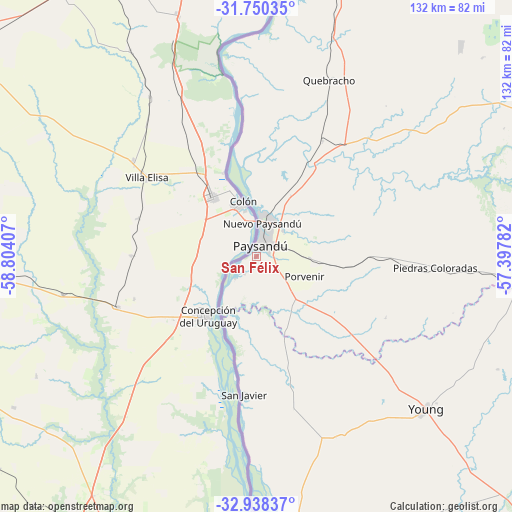
San Félix GPS coordinates[2]
32° 20' 46.716" South, 58° 6' 3.384" West
| Map corner | latitude | longitude |
|---|---|---|
| Upper-left | -31.75035°, | -58.80407° |
| Center: | -32.34631°, | -58.10094° |
| Lower-right: | -32.93837°, | -57.39782° |
| Map W x H: | 132.1×132.1 km | = 82.1×82.1mi |
| max Lat: | -30.25966° ⇑14.8% North |
| San Félix: | -32.34631° |
| min Lat: | ⇓85.2% South -34.94747° |
| min Long | San Félix | max Long |
| -58.41176° | -58.10094° | -53.38583° |
| W 4.9%⇐ | ⇒95.1% E |
Elevation
Elevation of San Félix is 7 m = 23 ft, and this is 63.6 m = 209 ft below average elevation for this country.
| Max E: |
294 m = 965 ft | 96.7% |
| Avg. | 70.6 m = 232 ft | |
| San Félix | 7 m = 23 ft | |
Min E: |
2 m = 7 ft | 3.3% |
See also: Uruguay elevation on elevation.city.
Geographical zone
San Félix is located in South temperate zone (between Tropic of Capricorn and the Antarctic Circle). Distance of this Southern Tropic circle is 990.7 km =615.6 mi to North.| Distance of | km | miles | from San Félix |
|---|---|---|---|
| Equator | 3596.6 | 2234.8 | to North |
| Tropic Capricorn | 990.7 | 615.6 | to North |
| Antarctic Circle | 3804.6 | 2364.1 | to South |
| South Pole | 6410.5 | 3983.3 | to South |


Nearby cities:
15 places around San Félix: (largest is in red/bold)
• Dolores
132.1 km =82.1 mi,  184°
184°
• Estación Porvenir
23.4 km =14.5 mi,  96°
96°
• Fray Bentos
87.9 km =54.6 mi,  192°
192°
• Guichón
84.8 km =52.7 mi,  90°
90°
• Mercedes
101 km =62.8 mi, 176°
• Nuevo Berlín
70.5 km =43.8 mi, 176°
• Palmitas
132.1 km =82.1 mi,  167°
167°
• Paysandú
3.8 km =2.4 mi,  30°
30°
• Piedras Coloradas
46.3 km =28.8 mi, 93°
• Quebracho
49.4 km =30.7 mi,  22°
22°
• Salto
107.8 km =67 mi,  6°
6°
• San Javier
35.6 km =22.1 mi, 184°
• Villa Constitución
144 km =89.5 mi, 9°
• Villa Soriano
118.8 km =73.8 mi, 190°
• Young
59.2 km =36.8 mi,  131°
131°
Sources, notices
• [Note1] Compared only with cities in Uruguay existing in our database
• [Src1] Map data: © OpenStreetMap contributors (CC-BY-SA)
• [Src2] Other city data from geonames.org with taken over terms of usage.
• [Src3] Geographical zone / Annual Mean Temperature by Robert A. Rohde @ Wikipedia
