Bella Unión geodata
Bella Unión (Artigas) is a populated place; located in Uruguay in America/Montevideo (GMT-3) time zone. With population of 13,171 people, there are 34 cities with bigger population in this country. Compared to other cities in Uruguay, 100% of cities are located further ↓South; 82.8% of cities are located further →East and 51.6% of cities have lower elevation than Bella Unión. Note1


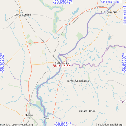
Bella Unión GPS coordinates[2]
30° 15' 34.776" South, 57° 35' 57.084" West
| Map corner | latitude | longitude |
|---|---|---|
| Upper-left | -29.65047°, | -58.30232° |
| Center: | -30.25966°, | -57.59919° |
| Lower-right: | -30.8651°, | -56.89607° |
| Map W x H: | 135.1×135.1 km | = 83.9×83.9mi |
| max Lat: | -30.25966° ⇑0% North |
| Bella Unión: | -30.25966° |
| min Lat: | ⇓100% South -34.94747° |
| min Long | Bella Unión | max Long |
| -58.41176° | -57.59919° | -53.38583° |
| W 17.2%⇐ | ⇒82.8% E |
Elevation
Elevation of Bella Unión is 53 m = 174 ft, and this is 17.6 m = 58 ft below average elevation for this country.
| Max E: |
294 m = 965 ft | 48.4% |
| Avg. | 70.6 m = 232 ft | |
| Bella Unión | 53 m = 174 ft | |
Min E: |
2 m = 7 ft | 51.6% |
See also: Uruguay elevation on elevation.city.
Geographical zone
Bella Unión is located in South temperate zone (between Tropic of Capricorn and the Antarctic Circle). Distance of this Southern Tropic circle is 758.6 km =471.4 mi to North.| Distance of | km | miles | from Bella Unión |
|---|---|---|---|
| Equator | 3364.6 | 2090.7 | to North |
| Tropic Capricorn | 758.6 | 471.4 | to North |
| Antarctic Circle | 4036.6 | 2508.2 | to South |
| South Pole | 6642.5 | 4127.5 | to South |


Nearby cities:
15 places around Bella Unión: (largest is in red/bold)
• Artigas
109.8 km =68.2 mi,  98°
98°
• Baltasar Brum
57.4 km =35.7 mi,  152°
152°
• Belén
61 km =37.9 mi,  196°
196°
• Estación Porvenir
236 km =146.6 mi,  185°
185°
• Guichón
236.5 km =147 mi,  170°
170°
• Las Piedras
1.7 km =1.1 mi, 98°
• Paysandú
233.3 km =145 mi, 191°
• Piedras Coloradas
234.9 km =146 mi,  180°
180°
• Quebracho
188.5 km =117.1 mi, 188°
• Rivera
208.8 km =129.7 mi,  110°
110°
• Salto
129.8 km =80.7 mi, 195°
• Tacuarembó
223.7 km =139 mi,  136°
136°
• Tomás Gomensoro
24.5 km =15.2 mi, 140°
• Tranqueras
205.3 km =127.6 mi,  120°
120°
• Villa Constitución
93.1 km =57.8 mi, 194°
Sources, notices
• [Note1] Compared only with cities in Uruguay existing in our database
• [Src1] Map data: © OpenStreetMap contributors (CC-BY-SA)
• [Src2] Other city data from geonames.org with taken over terms of usage.
• [Src3] Geographical zone / Annual Mean Temperature by Robert A. Rohde @ Wikipedia
