Belén geodata
Belén (Salto) is a populated place; located in Uruguay in America/Montevideo (GMT-3) time zone. With population of 2,033 people, there are 88 cities with bigger population in this country. Compared to other cities in Uruguay, 95.9% of cities are located further ↓South; 86.1% of cities are located further →East and 58.2% of cities have higher elevation than Belén. Note1


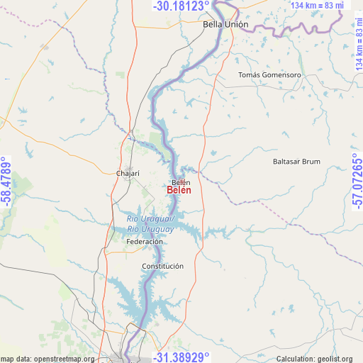
Belén GPS coordinates[2]
30° 47' 13.776" South, 57° 46' 32.772" West
| Map corner | latitude | longitude |
|---|---|---|
| Upper-left | -30.18123°, | -58.4789° |
| Center: | -30.78716°, | -57.77577° |
| Lower-right: | -31.38929°, | -57.07265° |
| Map W x H: | 134.3×134.3 km | = 83.5×83.5mi |
| max Lat: | -30.25966° ⇑4.1% North |
| Belén: | -30.78716° |
| min Lat: | ⇓95.9% South -34.94747° |
| min Long | Belén | max Long |
| -58.41176° | -57.77577° | -53.38583° |
| W 13.9%⇐ | ⇒86.1% E |
Elevation
Elevation of Belén is 44 m = 144 ft, and this is 26.6 m = 87 ft below average elevation for this country.
| Max E: |
294 m = 965 ft | 58.2% |
| Avg. | 70.6 m = 232 ft | |
| Belén | 44 m = 144 ft | |
Min E: |
2 m = 7 ft | 41.8% |
See also: Uruguay elevation on elevation.city.
Geographical zone
Belén is located in South temperate zone (between Tropic of Capricorn and the Antarctic Circle). Distance of this Southern Tropic circle is 817.3 km =507.8 mi to North.| Distance of | km | miles | from Belén |
|---|---|---|---|
| Equator | 3423.2 | 2127.1 | to North |
| Tropic Capricorn | 817.3 | 507.8 | to North |
| Antarctic Circle | 3978 | 2471.8 | to South |
| South Pole | 6583.9 | 4091 | to South |


Nearby cities:
15 places around Belén: (largest is in red/bold)
• Artigas
132.5 km =82.3 mi,  71°
71°
• Baltasar Brum
43.6 km =27.1 mi,  80°
80°
• Bella Unión
61 km =37.9 mi,  16°
16°
• Estación Porvenir
176.2 km =109.5 mi,  182°
182°
• Guichón
183.1 km =113.8 mi,  162°
162°
• Las Piedras
61.3 km =38.1 mi, 17°
• Paysandú
172.5 km =107.2 mi,  189°
189°
• Piedras Coloradas
176.9 km =109.9 mi,  174°
174°
• Quebracho
128.2 km =79.7 mi, 185°
• Salto
68.7 km =42.7 mi,  195°
195°
• San Félix
176.1 km =109.4 mi, 190°
• Tacuarembó
199.5 km =124 mi,  121°
121°
• Tomás Gomensoro
51.4 km =31.9 mi,  39°
39°
• Tranqueras
198.5 km =123.3 mi,  103°
103°
• Villa Constitución
32.1 km =19.9 mi, 192°
Sources, notices
• [Note1] Compared only with cities in Uruguay existing in our database
• [Src1] Map data: © OpenStreetMap contributors (CC-BY-SA)
• [Src2] Other city data from geonames.org with taken over terms of usage.
• [Src3] Geographical zone / Annual Mean Temperature by Robert A. Rohde @ Wikipedia
