Salto geodata
Salto is a seat of a first-order administrative division; located in Uruguay in America/Montevideo (GMT-3) time zone. With population of 99,823 people, there is 1 city with bigger population in this country. Compared to other cities in Uruguay, 92.6% of cities are located further ↓South; 91.8% of cities are located further →East and 81.1% of cities have higher elevation than Salto. Note1


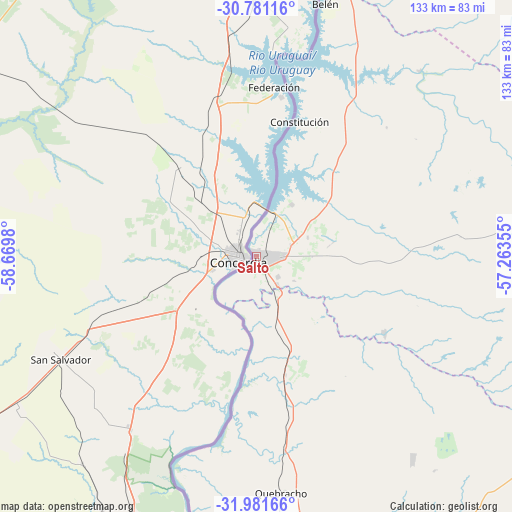
Salto GPS coordinates[2]
31° 22' 59.988" South, 57° 58' 0.012" West
| Map corner | latitude | longitude |
|---|---|---|
| Upper-left | -30.78116°, | -58.6698° |
| Center: | -31.38333°, | -57.96667° |
| Lower-right: | -31.98166°, | -57.26355° |
| Map W x H: | 133.5×133.5 km | = 83×83mi |
| max Lat: | -30.25966° ⇑7.4% North |
| Salto: | -31.38333° |
| min Lat: | ⇓92.6% South -34.94747° |
| min Long | Salto | max Long |
| -58.41176° | -57.96667° | -53.38583° |
| W 8.2%⇐ | ⇒91.8% E |
Elevation
Elevation of Salto is 18 m = 59 ft, and this is 52.6 m = 173 ft below average elevation for this country.
| Max E: |
294 m = 965 ft | 81.1% |
| Avg. | 70.6 m = 232 ft | |
| Salto | 18 m = 59 ft | |
Min E: |
2 m = 7 ft | 18.9% |
See also: Salto elevation on elevation.city.
Geographical zone
Salto is located in South temperate zone (between Tropic of Capricorn and the Antarctic Circle). Distance of this Southern Tropic circle is 883.6 km =549 mi to North.| Distance of | km | miles | from Salto |
|---|---|---|---|
| Equator | 3489.5 | 2168.3 | to North |
| Tropic Capricorn | 883.6 | 549 | to North |
| Antarctic Circle | 3911.7 | 2430.6 | to South |
| South Pole | 6517.6 | 4049.8 | to South |


Nearby cities:
15 places around Salto: (largest is in red/bold)
• Baltasar Brum
95.8 km =59.5 mi,  39°
39°
• Bella Unión
129.8 km =80.7 mi,  15°
15°
• Belén
68.7 km =42.7 mi, 15°
• Estación Porvenir
110.3 km =68.5 mi,  174°
174°
• Guichón
130.5 km =81.1 mi,  146°
146°
• Las Piedras
130 km =80.8 mi, 16°
• Nuevo Berlín
177.7 km =110.4 mi,  182°
182°
• Paysandú
104.4 km =64.9 mi,  185°
185°
• Piedras Coloradas
115 km =71.5 mi,  162°
162°
• Quebracho
61.7 km =38.3 mi, 174°
• San Félix
107.8 km =67 mi, 186°
• San Javier
143.4 km =89.1 mi, 186°
• Tomás Gomensoro
117.6 km =73.1 mi,  25°
25°
• Villa Constitución
36.7 km =22.8 mi, 17°
• Young
149.7 km =93 mi, 167°
Sources, notices
• [Note1] Compared only with cities in Uruguay existing in our database
• [Src1] Map data: © OpenStreetMap contributors (CC-BY-SA)
• [Src2] Other city data from geonames.org with taken over terms of usage.
• [Src3] Geographical zone / Annual Mean Temperature by Robert A. Rohde @ Wikipedia
