Urgut geodata
Urgut (Samarqand) is a populated place; located in Uzbekistan in Asia/Samarkand (GMT+5) time zone. With population of 47,373 people, there are 33 cities with bigger population in this country. Compared to other cities in Uzbekistan, 85.1% of cities are located further ↑North; 51.1% of cities are located further →East and 96.6% of cities have lower elevation than Urgut. Note1


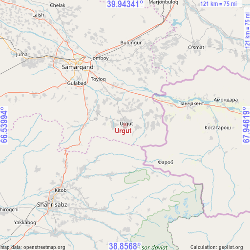
Urgut GPS coordinates[2]
39° 24' 7.992" North, 67° 14' 35.016" East
| Map corner | latitude | longitude |
|---|---|---|
| Upper-left | 39.94341°, | 66.53994° |
| Center: | 39.40222°, | 67.24306° |
| Lower-right: | 38.8568°, | 67.94619° |
| Map W x H: | 120.8×120.8 km | = 75.1×75.1mi |
| max Lat: | 43.77877° ⇑85.1% North |
| Urgut: | 39.40222° |
| min Lat: | ⇓14.9% South 37.22417° |
| min Long | Urgut | max Long |
| 58.84596° | 67.24306° | 72.76177° |
| W 48.9%⇐ | ⇒51.1% E |
Elevation
Elevation of Urgut is 1013 m = 3323 ft, and this is 579.2 m = 1900 ft above average elevation for this country.
| Max E: |
1464 m = 4803 ft | 3.4% |
| Urgut | 1013 m 3323 ft | |
| Avg. | 433.8 m = 1423 ft | |
Min E: |
50 m = 164 ft | 96.6% |
See also: Urgut elevation on elevation.city.
Geographical zone
Urgut is located in North temperate zone (between Tropic of Cancer and the Arctic Circle). Distance of this Northern Tropic circle is 1775.2 km =1103.1 mi to South.| Distance of | km | miles | from Urgut |
|---|---|---|---|
| North Pole | 5625.9 | 3495.8 | to North |
| Arctic Circle | 3020.1 | 1876.6 | to North |
| Tropic Cancer | 1775.2 | 1103.1 | to South |
| Equator | 4381.1 | 2722.3 | to South |


Nearby cities:
15 places around Urgut: (largest is in red/bold)
• Bulung’ur
40.4 km =25.1 mi,  3°
3°
• Charxin
52.2 km =32.4 mi,  308°
308°
• Chelak
66.2 km =41.1 mi,  330°
330°
• Chiroqchi
70.8 km =44 mi,  234°
234°
• Chiroqchi Shahri
70.7 km =43.9 mi, 233°
• Daxbet
49.2 km =30.6 mi,  324°
324°
• Ishtixon
90.2 km =56 mi, 314°
• Jomboy
35.4 km =22 mi,  338°
338°
• Juma
60.7 km =37.7 mi, 305°
• Kitob
50 km =31.1 mi,  224°
224°
• Kitob Shahri
44.4 km =27.6 mi, 225°
• Samarkand
37.1 km =23.1 mi, 319°
• Shahrisabz
52 km =32.3 mi, 222°
• Shahrisabz Shahri
53.3 km =33.1 mi, 223°
• Yakkabog‘ Shahri
67.2 km =41.8 mi, 225°
Sources, notices
• [Note1] Compared only with cities in Uzbekistan existing in our database
• [Src1] Map data: © OpenStreetMap contributors (CC-BY-SA)
• [Src2] Other city data from geonames.org with taken over terms of usage.
• [Src3] Geographical zone / Annual Mean Temperature by Robert A. Rohde @ Wikipedia
