Jomboy geodata
Jomboy (Samarqand) is a populated place; located in Uzbekistan in Asia/Samarkand (GMT+5) time zone. With population of 14,429 people, there are 96 cities with bigger population in this country. Compared to other cities in Uzbekistan, 80.5% of cities are located further ↑North; 52.3% of cities are located further →East and 89.7% of cities have lower elevation than Jomboy. Note1


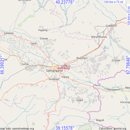
Jomboy GPS coordinates[2]
39° 41' 56.004" North, 67° 5' 35.988" East
| Map corner | latitude | longitude |
|---|---|---|
| Upper-left | 40.23776°, | 66.39021° |
| Center: | 39.69889°, | 67.09333° |
| Lower-right: | 39.15578°, | 67.79646° |
| Map W x H: | 120.3×120.3 km | = 74.8×74.8mi |
| max Lat: | 43.77877° ⇑80.5% North |
| Jomboy: | 39.69889° |
| min Lat: | ⇓19.5% South 37.22417° |
| min Long | Jomboy | max Long |
| 58.84596° | 67.09333° | 72.76177° |
| W 47.7%⇐ | ⇒52.3% E |
Elevation
Elevation of Jomboy is 708 m = 2323 ft, and this is 274.2 m = 900 ft above average elevation for this country.
| Max E: |
1464 m = 4803 ft | 10.3% |
| Jomboy | 708 m 2323 ft | |
| Avg. | 433.8 m = 1423 ft | |
Min E: |
50 m = 164 ft | 89.7% |
See also: Uzbekistan elevation on elevation.city.
Geographical zone
Jomboy is located in North temperate zone (between Tropic of Cancer and the Arctic Circle). Distance of this Northern Tropic circle is 1808.2 km =1123.6 mi to South.| Distance of | km | miles | from Jomboy |
|---|---|---|---|
| North Pole | 5593 | 3475.3 | to North |
| Arctic Circle | 2987.1 | 1856.1 | to North |
| Tropic Cancer | 1808.2 | 1123.6 | to South |
| Equator | 4414.1 | 2742.8 | to South |


Nearby cities:
15 places around Jomboy: (largest is in red/bold)
• Bulung’ur
16.9 km =10.5 mi,  64°
64°
• Charxin
27.8 km =17.3 mi,  269°
269°
• Chelak
31.6 km =19.6 mi,  321°
321°
• Daxbet
17.1 km =10.6 mi,  295°
295°
• Ishtixon
59.8 km =37.2 mi, 299°
• Jizzax
78.9 km =49 mi,  54°
54°
• Juma
36.8 km =22.9 mi, 272°
• Kattaqo‘rg‘on
74.9 km =46.5 mi,  287°
287°
• Kitob
71.9 km =44.7 mi,  198°
198°
• Kitob Shahri
66.8 km =41.5 mi, 196°
• Payshanba
80.8 km =50.2 mi, 295°
• Samarkand
12.5 km =7.8 mi,  246°
246°
• Shahrisabz
74.7 km =46.4 mi, 197°
• Shahrisabz Shahri
75.6 km =47 mi, 198°
• Urgut
35.4 km =22 mi,  158°
158°
Sources, notices
• [Note1] Compared only with cities in Uzbekistan existing in our database
• [Src1] Map data: © OpenStreetMap contributors (CC-BY-SA)
• [Src2] Other city data from geonames.org with taken over terms of usage.
• [Src3] Geographical zone / Annual Mean Temperature by Robert A. Rohde @ Wikipedia
