Chiroqchi geodata
Chiroqchi (Qashqadaryo) is a populated place; located in Uzbekistan in Asia/Samarkand (GMT+5) time zone. With population of 19,356 people, there are 86 cities with bigger population in this country. Compared to other cities in Uzbekistan, 90.2% of cities are located further ↑North; 59.2% of cities are located further →East and 71.3% of cities have lower elevation than Chiroqchi. Note1


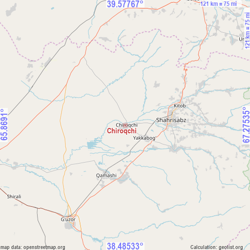
Chiroqchi GPS coordinates[2]
39° 2' 0.996" North, 66° 34' 19.992" East
| Map corner | latitude | longitude |
|---|---|---|
| Upper-left | 39.57767°, | 65.8691° |
| Center: | 39.03361°, | 66.57222° |
| Lower-right: | 38.48533°, | 67.27535° |
| Map W x H: | 121.5×121.5 km | = 75.5×75.5mi |
| max Lat: | 43.77877° ⇑90.2% North |
| Chiroqchi: | 39.03361° |
| min Lat: | ⇓9.8% South 37.22417° |
| min Long | Chiroqchi | max Long |
| 58.84596° | 66.57222° | 72.76177° |
| W 40.8%⇐ | ⇒59.2% E |
Elevation
Elevation of Chiroqchi is 524 m = 1719 ft, and this is 90.2 m = 296 ft above average elevation for this country.
| Max E: |
1464 m = 4803 ft | 28.7% |
| Chiroqchi | 524 m 1719 ft | |
| Avg. | 433.8 m = 1423 ft | |
Min E: |
50 m = 164 ft | 71.3% |
See also: Uzbekistan elevation on elevation.city.
Geographical zone
Chiroqchi is located in North temperate zone (between Tropic of Cancer and the Arctic Circle). Distance of this Northern Tropic circle is 1734.2 km =1077.6 mi to South.| Distance of | km | miles | from Chiroqchi |
|---|---|---|---|
| North Pole | 5666.9 | 3521.2 | to North |
| Arctic Circle | 3061 | 1902 | to North |
| Tropic Cancer | 1734.2 | 1077.6 | to South |
| Equator | 4340.1 | 2696.8 | to South |


Nearby cities:
15 places around Chiroqchi: (largest is in red/bold)
• Charxin
75.6 km =47 mi,  12°
12°
• Chiroqchi Shahri
1 km =0.6 mi,  133°
133°
• G‘uzor
53.8 km =33.4 mi,  211°
211°
• G‘uzor Shahri
53.5 km =33.2 mi, 212°
• Juma
76.3 km =47.4 mi, 5°
• Kitob
23.2 km =14.4 mi,  75°
75°
• Kitob Shahri
28 km =17.4 mi,  69°
69°
• Qamashi Shahri
25.5 km =15.8 mi,  201°
201°
• Qarshi
70.4 km =43.7 mi,  254°
254°
• Qorashina
76.9 km =47.8 mi,  180°
180°
• Samarkand
76.6 km =47.6 mi,  25°
25°
• Shahrisabz
22.8 km =14.2 mi, 83°
• Shahrisabz Shahri
21.6 km =13.4 mi, 84°
• Urgut
70.8 km =44 mi,  54°
54°
• Yakkabog‘ Shahri
11.9 km =7.4 mi,  122°
122°
Sources, notices
• [Note1] Compared only with cities in Uzbekistan existing in our database
• [Src1] Map data: © OpenStreetMap contributors (CC-BY-SA)
• [Src2] Other city data from geonames.org with taken over terms of usage.
• [Src3] Geographical zone / Annual Mean Temperature by Robert A. Rohde @ Wikipedia
