Bulung’ur geodata
Bulung’ur (Samarqand) is a populated place; located in Uzbekistan in Asia/Samarkand (GMT+5) time zone. With population of 26,815 people, there are 58 cities with bigger population in this country. Compared to other cities in Uzbekistan, 78.2% of cities are located further ↑North; 50.6% of cities are located further →East and 92.5% of cities have lower elevation than Bulung’ur. Note1


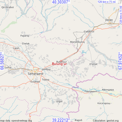
Bulung’ur GPS coordinates[2]
39° 45' 52.992" North, 67° 16' 17.004" East
| Map corner | latitude | longitude |
|---|---|---|
| Upper-left | 40.30307°, | 66.56827° |
| Center: | 39.76472°, | 67.27139° |
| Lower-right: | 39.22212°, | 67.97452° |
| Map W x H: | 120.2×120.2 km | = 74.7×74.7mi |
| max Lat: | 43.77877° ⇑78.2% North |
| Bulung’ur: | 39.76472° |
| min Lat: | ⇓21.8% South 37.22417° |
| min Long | Bulung’ur | max Long |
| 58.84596° | 67.27139° | 72.76177° |
| W 49.4%⇐ | ⇒50.6% E |
Elevation
Elevation of Bulung’ur is 758 m = 2487 ft, and this is 324.2 m = 1064 ft above average elevation for this country.
| Max E: |
1464 m = 4803 ft | 7.5% |
| Bulung’ur | 758 m 2487 ft | |
| Avg. | 433.8 m = 1423 ft | |
Min E: |
50 m = 164 ft | 92.5% |
See also: Uzbekistan elevation on elevation.city.
Geographical zone
Bulung’ur is located in North temperate zone (between Tropic of Cancer and the Arctic Circle). Distance of this Northern Tropic circle is 1815.5 km =1128.1 mi to South.| Distance of | km | miles | from Bulung’ur |
|---|---|---|---|
| North Pole | 5585.6 | 3470.7 | to North |
| Arctic Circle | 2979.8 | 1851.6 | to North |
| Tropic Cancer | 1815.5 | 1128.1 | to South |
| Equator | 4421.4 | 2747.3 | to South |


Nearby cities:
15 places around Bulung’ur: (largest is in red/bold)
• Charxin
43.7 km =27.2 mi,  260°
260°
• Chelak
39.1 km =24.3 mi,  296°
296°
• Daxbet
30.7 km =19.1 mi,  269°
269°
• Ishtixon
70.7 km =43.9 mi,  288°
288°
• Jizzax
62.4 km =38.8 mi,  51°
51°
• Jomboy
16.9 km =10.5 mi,  244°
244°
• Juma
52.2 km =32.4 mi, 264°
• Kattaqo‘rg‘on
88 km =54.7 mi,  279°
279°
• Kitob
84.5 km =52.5 mi,  206°
206°
• Kitob Shahri
79.1 km =49.2 mi, 205°
• Paxtakor
84.4 km =52.4 mi,  43°
43°
• Samarkand
29.4 km =18.3 mi,  245°
245°
• Shahrisabz
87.1 km =54.1 mi, 205°
• Shahrisabz Shahri
88.2 km =54.8 mi, 206°
• Urgut
40.4 km =25.1 mi,  183°
183°
Sources, notices
• [Note1] Compared only with cities in Uzbekistan existing in our database
• [Src1] Map data: © OpenStreetMap contributors (CC-BY-SA)
• [Src2] Other city data from geonames.org with taken over terms of usage.
• [Src3] Geographical zone / Annual Mean Temperature by Robert A. Rohde @ Wikipedia
