Juma geodata
Juma (Samarqand) is a populated place; located in Uzbekistan in Asia/Samarkand (GMT+5) time zone. With population of 19,920 people, there are 83 cities with bigger population in this country. Compared to other cities in Uzbekistan, 79.9% of cities are located further ↑North; 58% of cities are located further →East and 82.2% of cities have lower elevation than Juma. Note1


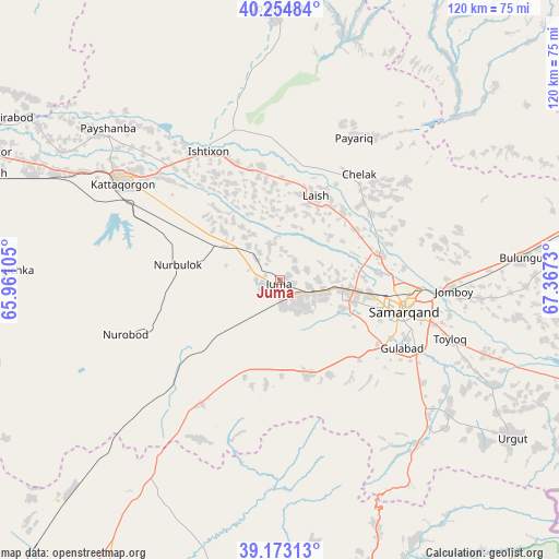
Juma GPS coordinates[2]
39° 42' 57.996" North, 66° 39' 51.012" East
| Map corner | latitude | longitude |
|---|---|---|
| Upper-left | 40.25484°, | 65.96105° |
| Center: | 39.71611°, | 66.66417° |
| Lower-right: | 39.17313°, | 67.3673° |
| Map W x H: | 120.3×120.3 km | = 74.8×74.8mi |
| max Lat: | 43.77877° ⇑79.9% North |
| Juma: | 39.71611° |
| min Lat: | ⇓20.1% South 37.22417° |
| min Long | Juma | max Long |
| 58.84596° | 66.66417° | 72.76177° |
| W 42%⇐ | ⇒58% E |
Elevation
Elevation of Juma is 626 m = 2054 ft, and this is 192.2 m = 631 ft above average elevation for this country.
| Max E: |
1464 m = 4803 ft | 17.8% |
| Juma | 626 m 2054 ft | |
| Avg. | 433.8 m = 1423 ft | |
Min E: |
50 m = 164 ft | 82.2% |
See also: Uzbekistan elevation on elevation.city.
Geographical zone
Juma is located in North temperate zone (between Tropic of Cancer and the Arctic Circle). Distance of this Northern Tropic circle is 1810.1 km =1124.7 mi to South.| Distance of | km | miles | from Juma |
|---|---|---|---|
| North Pole | 5591 | 3474.1 | to North |
| Arctic Circle | 2985.2 | 1854.9 | to North |
| Tropic Cancer | 1810.1 | 1124.7 | to South |
| Equator | 4416 | 2744 | to South |


Nearby cities:
15 places around Juma: (largest is in red/bold)
• Bulung’ur
52.2 km =32.4 mi,  84°
84°
• Charxin
9.2 km =5.7 mi,  103°
103°
• Chelak
28.3 km =17.6 mi,  36°
36°
• Daxbet
21.9 km =13.6 mi, 75°
• Ishtixon
31.7 km =19.7 mi,  331°
331°
• Jomboy
36.8 km =22.9 mi,  92°
92°
• Kattaqo‘rg‘on
40.3 km =25 mi,  300°
300°
• Kitob
71.7 km =44.6 mi,  168°
168°
• Kitob Shahri
68.5 km =42.6 mi,  164°
164°
• Oqtosh
67.1 km =41.7 mi,  289°
289°
• Payshanba
48.8 km =30.3 mi,  311°
311°
• Samarkand
26.2 km =16.3 mi,  105°
105°
• Shahrisabz
74.6 km =46.4 mi, 168°
• Urgut
60.7 km =37.7 mi,  125°
125°
• Yangirabot
69.2 km =43 mi, 299°
Sources, notices
• [Note1] Compared only with cities in Uzbekistan existing in our database
• [Src1] Map data: © OpenStreetMap contributors (CC-BY-SA)
• [Src2] Other city data from geonames.org with taken over terms of usage.
• [Src3] Geographical zone / Annual Mean Temperature by Robert A. Rohde @ Wikipedia
