Samarkand geodata
Samarkand (Samarqand) is a seat of a first-order administrative division; located in Uzbekistan in Asia/Samarkand (GMT+5) time zone. With population of 319,366 people, there are 2 cities with bigger population in this country. Compared to other cities in Uzbekistan, 81.6% of cities are located further ↑North; 52.9% of cities are located further →East and 90.8% of cities have lower elevation than Samarkand. Note1


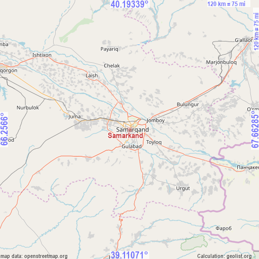
Samarkand GPS coordinates[2]
39° 39' 15.012" North, 66° 57' 34.992" East
| Map corner | latitude | longitude |
|---|---|---|
| Upper-left | 40.19339°, | 66.2566° |
| Center: | 39.65417°, | 66.95972° |
| Lower-right: | 39.11071°, | 67.66285° |
| Map W x H: | 120.4×120.4 km | = 74.8×74.8mi |
| max Lat: | 43.77877° ⇑81.6% North |
| Samarkand: | 39.65417° |
| min Lat: | ⇓18.4% South 37.22417° |
| min Long | Samarkand | max Long |
| 58.84596° | 66.95972° | 72.76177° |
| W 47.1%⇐ | ⇒52.9% E |
Elevation
Elevation of Samarkand is 719 m = 2359 ft, and this is 285.2 m = 936 ft above average elevation for this country.
| Max E: |
1464 m = 4803 ft | 9.2% |
| Samarkand | 719 m 2359 ft | |
| Avg. | 433.8 m = 1423 ft | |
Min E: |
50 m = 164 ft | 90.8% |
See also: Samarkand elevation on elevation.city.
Geographical zone
Samarkand is located in North temperate zone (between Tropic of Cancer and the Arctic Circle). Distance of this Northern Tropic circle is 1803.2 km =1120.5 mi to South.| Distance of | km | miles | from Samarkand |
|---|---|---|---|
| North Pole | 5597.9 | 3478.4 | to North |
| Arctic Circle | 2992 | 1859.1 | to North |
| Tropic Cancer | 1803.2 | 1120.5 | to South |
| Equator | 4409.1 | 2739.7 | to South |


Nearby cities:
15 places around Samarkand: (largest is in red/bold)
• Bulung’ur
29.4 km =18.3 mi,  65°
65°
• Charxin
17 km =10.6 mi,  286°
286°
• Chelak
30.8 km =19.1 mi,  344°
344°
• Chiroqchi
76.6 km =47.6 mi,  205°
205°
• Daxbet
12.9 km =8 mi, 341°
• Ishtixon
53.3 km =33.1 mi,  310°
310°
• Jomboy
12.5 km =7.8 mi, 66°
• Juma
26.2 km =16.3 mi, 285°
• Kattaqo‘rg‘on
66 km =41 mi, 294°
• Kitob
64.3 km =40 mi,  189°
189°
• Kitob Shahri
59.6 km =37 mi, 186°
• Payshanba
73.2 km =45.5 mi,  302°
302°
• Shahrisabz
67.2 km =41.8 mi, 189°
• Shahrisabz Shahri
68 km =42.3 mi, 190°
• Urgut
37.1 km =23.1 mi,  139°
139°
In other languages:
- In Spanish: Samarkanda, Samarcanda
- In France: Samarcande
- In German: Samarqand
- In Italian: Samarcanda
- In Russian: Самарканд
- In Chinese: 撒马尔罕, 撒馬爾罕
Sources, notices
• [Note1] Compared only with cities in Uzbekistan existing in our database
• [Src1] Map data: © OpenStreetMap contributors (CC-BY-SA)
• [Src2] Other city data from geonames.org with taken over terms of usage.
• [Src3] Geographical zone / Annual Mean Temperature by Robert A. Rohde @ Wikipedia
