Romiton geodata
Romiton (Bukhara) is a populated place; located in Uzbekistan in Asia/Samarkand (GMT+5) time zone. With population of 12,927 people, there are 105 cities with bigger population in this country. Compared to other cities in Uzbekistan, 74.7% of cities are located further ↑North; 81% of cities are located further →East and 80.5% of cities have higher elevation than Romiton. Note1


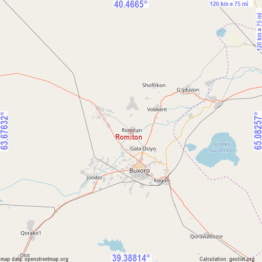
Romiton GPS coordinates[2]
39° 55' 45.984" North, 64° 22' 45.984" East
| Map corner | latitude | longitude |
|---|---|---|
| Upper-left | 40.4665°, | 63.67632° |
| Center: | 39.92944°, | 64.37944° |
| Lower-right: | 39.38814°, | 65.08257° |
| Map W x H: | 119.9×119.9 km | = 74.5×74.5mi |
| max Lat: | 43.77877° ⇑74.7% North |
| Romiton: | 39.92944° |
| min Lat: | ⇓25.3% South 37.22417° |
| min Long | Romiton | max Long |
| 58.84596° | 64.37944° | 72.76177° |
| W 19%⇐ | ⇒81% E |
Elevation
Elevation of Romiton is 228 m = 748 ft, and this is 205.8 m = 675 ft below average elevation for this country.
| Max E: |
1464 m = 4803 ft | 80.5% |
| Avg. | 433.8 m = 1423 ft | |
| Romiton | 228 m = 748 ft | |
Min E: |
50 m = 164 ft | 19.5% |
See also: Uzbekistan elevation on elevation.city.
Geographical zone
Romiton is located in North temperate zone (between Tropic of Cancer and the Arctic Circle). Distance of this Northern Tropic circle is 1833.8 km =1139.5 mi to South.| Distance of | km | miles | from Romiton |
|---|---|---|---|
| North Pole | 5567.3 | 3459.4 | to North |
| Arctic Circle | 2961.4 | 1840.1 | to North |
| Tropic Cancer | 1833.8 | 1139.5 | to South |
| Equator | 4439.7 | 2758.7 | to South |


Nearby cities:
15 places around Romiton: (largest is in red/bold)
• Bukhara
17.7 km =11 mi,  166°
166°
• Galaosiyo
9.9 km =6.2 mi,  143°
143°
• Gazli
82.3 km =51.1 mi,  285°
285°
• Ghijduwon
32.1 km =19.9 mi,  53°
53°
• Karakul’
64.2 km =39.9 mi,  226°
226°
• Kogon
27.3 km =17 mi,  147°
147°
• Konimex
75.7 km =47 mi,  59°
59°
• Olot
75.5 km =46.9 mi,  220°
220°
• Qiziltepa
41.7 km =25.9 mi,  73°
73°
• Qiziltepa Shahri
39.8 km =24.7 mi, 74°
• Qorako’l
65.6 km =40.8 mi, 223°
• Qorovulbozor
59.4 km =36.9 mi, 143°
• Qorovulbozor Shahri
60.1 km =37.3 mi, 142°
• Shofirkon
23.6 km =14.7 mi,  26°
26°
• Wobkent
16.1 km =10 mi, 45°
Sources, notices
• [Note1] Compared only with cities in Uzbekistan existing in our database
• [Src1] Map data: © OpenStreetMap contributors (CC-BY-SA)
• [Src2] Other city data from geonames.org with taken over terms of usage.
• [Src3] Geographical zone / Annual Mean Temperature by Robert A. Rohde @ Wikipedia
