Galaosiyo geodata
Galaosiyo (Bukhara) is a populated place; located in Uzbekistan in Asia/Samarkand (GMT+5) time zone. With population of 15,620 people, there are 94 cities with bigger population in this country. Compared to other cities in Uzbekistan, 77% of cities are located further ↑North; 79.9% of cities are located further →East and 80.5% of cities have higher elevation than Galaosiyo. Note1


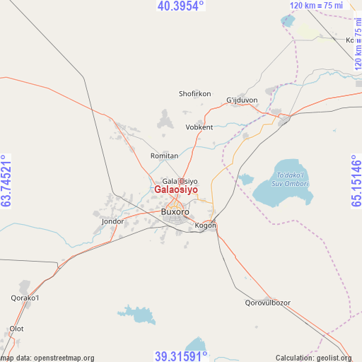
Galaosiyo GPS coordinates[2]
39° 51' 28.008" North, 64° 26' 53.988" East
| Map corner | latitude | longitude |
|---|---|---|
| Upper-left | 40.3954°, | 63.74521° |
| Center: | 39.85778°, | 64.44833° |
| Lower-right: | 39.31591°, | 65.15146° |
| Map W x H: | 120×120 km | = 74.6×74.6mi |
| max Lat: | 43.77877° ⇑77% North |
| Galaosiyo: | 39.85778° |
| min Lat: | ⇓23% South 37.22417° |
| min Long | Galaosiyo | max Long |
| 58.84596° | 64.44833° | 72.76177° |
| W 20.1%⇐ | ⇒79.9% E |
Elevation
Elevation of Galaosiyo is 228 m = 748 ft, and this is 205.8 m = 675 ft below average elevation for this country.
| Max E: |
1464 m = 4803 ft | 80.5% |
| Avg. | 433.8 m = 1423 ft | |
| Galaosiyo | 228 m = 748 ft | |
Min E: |
50 m = 164 ft | 19.5% |
See also: Uzbekistan elevation on elevation.city.
Geographical zone
Galaosiyo is located in North temperate zone (between Tropic of Cancer and the Arctic Circle). Distance of this Northern Tropic circle is 1825.9 km =1134.6 mi to South.| Distance of | km | miles | from Galaosiyo |
|---|---|---|---|
| North Pole | 5575.3 | 3464.3 | to North |
| Arctic Circle | 2969.4 | 1845.1 | to North |
| Tropic Cancer | 1825.9 | 1134.6 | to South |
| Equator | 4431.8 | 2753.8 | to South |


Nearby cities:
15 places around Galaosiyo: (largest is in red/bold)
• Bukhara
9.4 km =5.8 mi,  190°
190°
• Ghijduwon
33.6 km =20.9 mi,  36°
36°
• Karakul’
63.8 km =39.6 mi,  235°
235°
• Kogon
17.4 km =10.8 mi,  149°
149°
• Konimex
75.3 km =46.8 mi,  51°
51°
• Navoiy
83.2 km =51.7 mi,  72°
72°
• Olot
74 km =46 mi,  228°
228°
• Qiziltepa
39.4 km =24.5 mi,  60°
60°
• Qiziltepa Shahri
37.4 km =23.2 mi, 60°
• Qorako’l
64.6 km =40.1 mi, 231°
• Qorovulbozor
49.5 km =30.8 mi,  143°
143°
• Qorovulbozor Shahri
50.2 km =31.2 mi, 141°
• Romiton
9.9 km =6.2 mi,  323°
323°
• Shofirkon
29.5 km =18.3 mi,  8°
8°
• Wobkent
20 km =12.4 mi,  16°
16°
Sources, notices
• [Note1] Compared only with cities in Uzbekistan existing in our database
• [Src1] Map data: © OpenStreetMap contributors (CC-BY-SA)
• [Src2] Other city data from geonames.org with taken over terms of usage.
• [Src3] Geographical zone / Annual Mean Temperature by Robert A. Rohde @ Wikipedia
