Olot geodata
Olot (Bukhara) is a populated place; located in Uzbekistan in Asia/Samarkand (GMT+5) time zone. With population of 11,984 people, there are 106 cities with bigger population in this country. Compared to other cities in Uzbekistan, 84.5% of cities are located further ↑North; 82.8% of cities are located further →East and 83.3% of cities have higher elevation than Olot. Note1


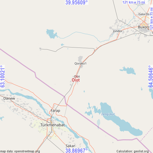
Olot GPS coordinates[2]
39° 24' 54" North, 63° 48' 11.988" East
| Map corner | latitude | longitude |
|---|---|---|
| Upper-left | 39.95609°, | 63.10021° |
| Center: | 39.415°, | 63.80333° |
| Lower-right: | 38.86967°, | 64.50646° |
| Map W x H: | 120.8×120.8 km | = 75.1×75.1mi |
| max Lat: | 43.77877° ⇑84.5% North |
| Olot: | 39.415° |
| min Lat: | ⇓15.5% South 37.22417° |
| min Long | Olot | max Long |
| 58.84596° | 63.80333° | 72.76177° |
| W 17.2%⇐ | ⇒82.8% E |
Elevation
Elevation of Olot is 197 m = 646 ft, and this is 236.8 m = 777 ft below average elevation for this country.
| Max E: |
1464 m = 4803 ft | 83.3% |
| Avg. | 433.8 m = 1423 ft | |
| Olot | 197 m = 646 ft | |
Min E: |
50 m = 164 ft | 16.7% |
See also: Uzbekistan elevation on elevation.city.
Geographical zone
Olot is located in North temperate zone (between Tropic of Cancer and the Arctic Circle). Distance of this Northern Tropic circle is 1776.6 km =1103.9 mi to South.| Distance of | km | miles | from Olot |
|---|---|---|---|
| North Pole | 5624.5 | 3494.9 | to North |
| Arctic Circle | 3018.6 | 1875.7 | to North |
| Tropic Cancer | 1776.6 | 1103.9 | to South |
| Equator | 4382.5 | 2723.2 | to South |


Nearby cities:
15 places around Olot: (largest is in red/bold)
• Bukhara
66.9 km =41.6 mi,  53°
53°
• Galaosiyo
74 km =46 mi, 48°
• Gazli
85.4 km =53.1 mi,  339°
339°
• Ghijduwon
107 km =66.5 mi,  44°
44°
• Karakul’
13.4 km =8.3 mi,  11°
11°
• Kogon
72.7 km =45.2 mi,  61°
61°
• Muborak
117.4 km =72.9 mi,  98°
98°
• Qiziltepa
112.8 km =70.1 mi, 52°
• Qiziltepa Shahri
110.9 km =68.9 mi, 52°
• Qorako’l
10.3 km =6.4 mi,  24°
24°
• Qorovulbozor
85.5 km =53.1 mi,  83°
83°
• Qorovulbozor Shahri
87.1 km =54.1 mi, 83°
• Romiton
75.5 km =46.9 mi, 40°
• Shofirkon
98.5 km =61.2 mi, 37°
• Wobkent
91.6 km =56.9 mi, 41°
Sources, notices
• [Note1] Compared only with cities in Uzbekistan existing in our database
• [Src1] Map data: © OpenStreetMap contributors (CC-BY-SA)
• [Src2] Other city data from geonames.org with taken over terms of usage.
• [Src3] Geographical zone / Annual Mean Temperature by Robert A. Rohde @ Wikipedia
