Wobkent geodata
Wobkent (Bukhara) is a populated place; located in Uzbekistan in Asia/Samarkand (GMT+5) time zone. With population of 16,697 people, there are 92 cities with bigger population in this country. Compared to other cities in Uzbekistan, 70.1% of cities are located further ↑North; 78.7% of cities are located further →East and 78.7% of cities have higher elevation than Wobkent. Note1


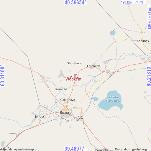
Wobkent GPS coordinates[2]
40° 1' 49.008" North, 64° 30' 54" East
| Map corner | latitude | longitude |
|---|---|---|
| Upper-left | 40.56654°, | 63.81188° |
| Center: | 40.03028°, | 64.515° |
| Lower-right: | 39.48977°, | 65.21813° |
| Map W x H: | 119.7×119.7 km | = 74.4×74.4mi |
| max Lat: | 43.77877° ⇑70.1% North |
| Wobkent: | 40.03028° |
| min Lat: | ⇓29.9% South 37.22417° |
| min Long | Wobkent | max Long |
| 58.84596° | 64.515° | 72.76177° |
| W 21.3%⇐ | ⇒78.7% E |
Elevation
Elevation of Wobkent is 243 m = 797 ft, and this is 190.8 m = 626 ft below average elevation for this country.
| Max E: |
1464 m = 4803 ft | 78.7% |
| Avg. | 433.8 m = 1423 ft | |
| Wobkent | 243 m = 797 ft | |
Min E: |
50 m = 164 ft | 21.3% |
See also: Uzbekistan elevation on elevation.city.
Geographical zone
Wobkent is located in North temperate zone (between Tropic of Cancer and the Arctic Circle). Distance of this Northern Tropic circle is 1845 km =1146.4 mi to South.| Distance of | km | miles | from Wobkent |
|---|---|---|---|
| North Pole | 5556.1 | 3452.4 | to North |
| Arctic Circle | 2950.2 | 1833.2 | to North |
| Tropic Cancer | 1845 | 1146.4 | to South |
| Equator | 4450.9 | 2765.7 | to South |


Nearby cities:
15 places around Wobkent: (largest is in red/bold)
• Beshrabot
72.2 km =44.9 mi,  75°
75°
• Bukhara
29.4 km =18.3 mi,  194°
194°
• Galaosiyo
20 km =12.4 mi,  196°
196°
• Ghijduwon
16.3 km =10.1 mi,  61°
61°
• Karakul’
80.3 km =49.9 mi,  226°
226°
• Karmana Shahri
74.2 km =46.1 mi, 80°
• Kogon
34.3 km =21.3 mi,  174°
174°
• Konimex
60.1 km =37.3 mi, 62°
• Navoiy
73.8 km =45.9 mi,  85°
85°
• Qiziltepa
28.5 km =17.7 mi, 89°
• Qiziltepa Shahri
26.7 km =16.6 mi, 91°
• Qorovulbozor
63.5 km =39.5 mi,  157°
157°
• Qorovulbozor Shahri
63.9 km =39.7 mi, 156°
• Romiton
16.1 km =10 mi, 225°
• Shofirkon
10 km =6.2 mi,  353°
353°
Sources, notices
• [Note1] Compared only with cities in Uzbekistan existing in our database
• [Src1] Map data: © OpenStreetMap contributors (CC-BY-SA)
• [Src2] Other city data from geonames.org with taken over terms of usage.
• [Src3] Geographical zone / Annual Mean Temperature by Robert A. Rohde @ Wikipedia
