Qarshi geodata
Qarshi (Qashqadaryo) is a seat of a first-order administrative division; located in Uzbekistan in Asia/Samarkand (GMT+5) time zone. With population of 222,898 people, there are 6 cities with bigger population in this country. Compared to other cities in Uzbekistan, 92.5% of cities are located further ↑North; 64.9% of cities are located further →East and 58.6% of cities have higher elevation than Qarshi. Note1


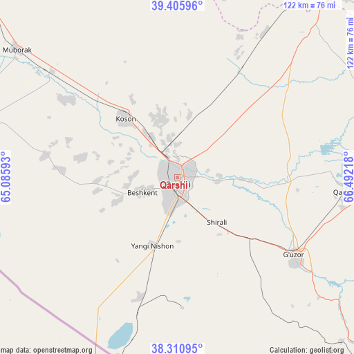
Qarshi GPS coordinates[2]
38° 51' 38.016" North, 65° 47' 20.58" East
| Map corner | latitude | longitude |
|---|---|---|
| Upper-left | 39.40596°, | 65.08593° |
| Center: | 38.86056°, | 65.78905° |
| Lower-right: | 38.31095°, | 66.49218° |
| Map W x H: | 121.8×121.8 km | = 75.7×75.7mi |
| max Lat: | 43.77877° ⇑92.5% North |
| Qarshi: | 38.86056° |
| min Lat: | ⇓7.5% South 37.22417° |
| min Long | Qarshi | max Long |
| 58.84596° | 65.78905° | 72.76177° |
| W 35.1%⇐ | ⇒64.9% E |
Elevation
Elevation of Qarshi is 383 m = 1257 ft, and this is 50.8 m = 167 ft below average elevation for this country.
| Max E: |
1464 m = 4803 ft | 58.6% |
| Avg. | 433.8 m = 1423 ft | |
| Qarshi | 383 m = 1257 ft | |
Min E: |
50 m = 164 ft | 41.4% |
See also: Qarshi elevation on elevation.city.
Geographical zone
Qarshi is located in North temperate zone (between Tropic of Cancer and the Arctic Circle). Distance of this Northern Tropic circle is 1715 km =1065.7 mi to South.| Distance of | km | miles | from Qarshi |
|---|---|---|---|
| North Pole | 5686.2 | 3533.2 | to North |
| Arctic Circle | 3080.3 | 1914 | to North |
| Tropic Cancer | 1715 | 1065.7 | to South |
| Equator | 4320.9 | 2684.9 | to South |


Nearby cities:
15 places around Qarshi: (largest is in red/bold)
• Beshkent
12.6 km =7.8 mi,  249°
249°
• Beshkent Shahri
13.8 km =8.6 mi, 246°
• Chiroqchi
70.4 km =43.7 mi,  74°
74°
• Chiroqchi Shahri
70.9 km =44.1 mi, 74°
• G‘uzor
47.9 km =29.8 mi,  123°
123°
• G‘uzor Shahri
47.4 km =29.5 mi, 123°
• Koson
26.4 km =16.4 mi,  318°
318°
• Koson Shahri
26.7 km =16.6 mi, 320°
• Muborak
70.3 km =43.7 mi,  308°
308°
• Muborak Shahri
70.2 km =43.6 mi, 308°
• Mug‘lon Shahar
33.3 km =20.7 mi,  281°
281°
• Nishon Tumani
21 km =13 mi,  208°
208°
• Qamashi Shahri
58.7 km =36.5 mi,  94°
94°
• Yangi Mirishkor
44.3 km =27.5 mi,  268°
268°
• Yangi-Nishon Shahri
25.5 km =15.8 mi,  199°
199°
Sources, notices
• [Note1] Compared only with cities in Uzbekistan existing in our database
• [Src1] Map data: © OpenStreetMap contributors (CC-BY-SA)
• [Src2] Other city data from geonames.org with taken over terms of usage.
• [Src3] Geographical zone / Annual Mean Temperature by Robert A. Rohde @ Wikipedia
