G‘uzor geodata
G‘uzor (Qashqadaryo) is a populated place; located in Uzbekistan in Asia/Samarkand (GMT+5) time zone. With population of 25,368 people, there are 66 cities with bigger population in this country. Compared to other cities in Uzbekistan, 97.1% of cities are located further ↑North; 62.1% of cities are located further →East and 71.3% of cities have lower elevation than G‘uzor. Note1


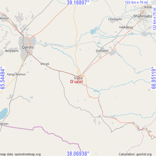
G‘uzor GPS coordinates[2]
38° 37' 14.988" North, 66° 14' 53.016" East
| Map corner | latitude | longitude |
|---|---|---|
| Upper-left | 39.16807°, | 65.54494° |
| Center: | 38.62083°, | 66.24806° |
| Lower-right: | 38.06938°, | 66.95119° |
| Map W x H: | 122.2×122.2 km | = 75.9×75.9mi |
| max Lat: | 43.77877° ⇑97.1% North |
| G‘uzor: | 38.62083° |
| min Lat: | ⇓2.9% South 37.22417° |
| min Long | G‘uzor | max Long |
| 58.84596° | 66.24806° | 72.76177° |
| W 37.9%⇐ | ⇒62.1% E |
Elevation
Elevation of G‘uzor is 524 m = 1719 ft, and this is 90.2 m = 296 ft above average elevation for this country.
| Max E: |
1464 m = 4803 ft | 28.7% |
| G‘uzor | 524 m 1719 ft | |
| Avg. | 433.8 m = 1423 ft | |
Min E: |
50 m = 164 ft | 71.3% |
See also: Uzbekistan elevation on elevation.city.
Geographical zone
G‘uzor is located in North temperate zone (between Tropic of Cancer and the Arctic Circle). Distance of this Northern Tropic circle is 1688.3 km =1049.1 mi to South.| Distance of | km | miles | from G‘uzor |
|---|---|---|---|
| North Pole | 5712.8 | 3549.8 | to North |
| Arctic Circle | 3106.9 | 1930.5 | to North |
| Tropic Cancer | 1688.3 | 1049.1 | to South |
| Equator | 4294.2 | 2668.3 | to South |


Nearby cities:
15 places around G‘uzor: (largest is in red/bold)
• Beshkent
56.2 km =34.9 mi,  293°
293°
• Beshkent Shahri
56.6 km =35.2 mi, 291°
• Chiroqchi
53.8 km =33.4 mi,  31°
31°
• Chiroqchi Shahri
53.6 km =33.3 mi, 32°
• G‘uzor Shahri
0.6 km =0.4 mi,  336°
336°
• Kitob
72.3 km =44.9 mi,  44°
44°
• Koson
73.8 km =45.9 mi,  308°
308°
• Nishon Tumani
50.4 km =31.3 mi,  279°
279°
• Qamashi Shahri
29 km =18 mi, 40°
• Qarshi
47.9 km =29.8 mi,  303°
303°
• Qorashina
41.4 km =25.7 mi,  138°
138°
• Shahrisabz
70.3 km =43.7 mi,  46°
46°
• Shahrisabz Shahri
69 km =42.9 mi, 45°
• Yakkabog‘ Shahri
55 km =34.2 mi, 43°
• Yangi-Nishon Shahri
48.6 km =30.2 mi,  273°
273°
Sources, notices
• [Note1] Compared only with cities in Uzbekistan existing in our database
• [Src1] Map data: © OpenStreetMap contributors (CC-BY-SA)
• [Src2] Other city data from geonames.org with taken over terms of usage.
• [Src3] Geographical zone / Annual Mean Temperature by Robert A. Rohde @ Wikipedia
