Nishon Tumani geodata
Nishon Tumani (Qashqadaryo) is a populated place; located in Uzbekistan in Asia/Samarkand (GMT+5) time zone. With population of 10,558 people, there are 108 cities with bigger population in this country. Compared to other cities in Uzbekistan, 95.4% of cities are located further ↑North; 67.2% of cities are located further →East and 62.1% of cities have higher elevation than Nishon Tumani. Note1


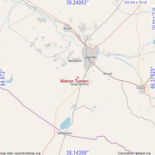
Nishon Tumani GPS coordinates[2]
38° 41' 38.22" North, 65° 40' 30.432" East
| Map corner | latitude | longitude |
|---|---|---|
| Upper-left | 39.24063°, | 64.972° |
| Center: | 38.69395°, | 65.67512° |
| Lower-right: | 38.14306°, | 66.37825° |
| Map W x H: | 122×122 km | = 75.8×75.8mi |
| max Lat: | 43.77877° ⇑95.4% North |
| Nishon Tumani: | 38.69395° |
| min Lat: | ⇓4.6% South 37.22417° |
| min Long | Nishon Tumani | max Long |
| 58.84596° | 65.67512° | 72.76177° |
| W 32.8%⇐ | ⇒67.2% E |
Elevation
Elevation of Nishon Tumani is 349 m = 1145 ft, and this is 84.8 m = 278 ft below average elevation for this country.
| Max E: |
1464 m = 4803 ft | 62.1% |
| Avg. | 433.8 m = 1423 ft | |
| Nishon Tumani | 349 m = 1145 ft | |
Min E: |
50 m = 164 ft | 37.9% |
See also: Uzbekistan elevation on elevation.city.
Geographical zone
Nishon Tumani is located in North temperate zone (between Tropic of Cancer and the Arctic Circle). Distance of this Northern Tropic circle is 1696.4 km =1054.1 mi to South.| Distance of | km | miles | from Nishon Tumani |
|---|---|---|---|
| North Pole | 5704.7 | 3544.7 | to North |
| Arctic Circle | 3098.8 | 1925.5 | to North |
| Tropic Cancer | 1696.4 | 1054.1 | to South |
| Equator | 4302.4 | 2673.4 | to South |


Nearby cities:
15 places around Nishon Tumani: (largest is in red/bold)
• Beshkent
14.3 km =8.9 mi,  352°
352°
• Beshkent Shahri
13.3 km =8.3 mi, 347°
• Chiroqchi
86.4 km =53.7 mi,  64°
64°
• G‘uzor
50.4 km =31.3 mi,  99°
99°
• G‘uzor Shahri
50.1 km =31.1 mi, 98°
• Koson
39 km =24.2 mi, 348°
• Koson Shahri
39.7 km =24.7 mi, 349°
• Muborak
77 km =47.8 mi,  324°
324°
• Muborak Shahri
77.1 km =47.9 mi, 324°
• Mug‘lon Shahar
33.8 km =21 mi, 317°
• Qamashi Shahri
69.9 km =43.4 mi,  78°
78°
• Qarshi
21 km =13 mi,  28°
28°
• Qorashina
86.6 km =53.8 mi,  116°
116°
• Yangi Mirishkor
38.6 km =24 mi,  296°
296°
• Yangi-Nishon Shahri
5.6 km =3.5 mi,  167°
167°
Sources, notices
• [Note1] Compared only with cities in Uzbekistan existing in our database
• [Src1] Map data: © OpenStreetMap contributors (CC-BY-SA)
• [Src2] Other city data from geonames.org with taken over terms of usage.
• [Src3] Geographical zone / Annual Mean Temperature by Robert A. Rohde @ Wikipedia
