Kattaqo‘rg‘on geodata
Kattaqo‘rg‘on (Samarqand) is a populated place; located in Uzbekistan in Asia/Samarkand (GMT+5) time zone. With population of 59,382 people, there are 23 cities with bigger population in this country. Compared to other cities in Uzbekistan, 76.4% of cities are located further ↑North; 61.5% of cities are located further →East and 62.6% of cities have lower elevation than Kattaqo‘rg‘on. Note1


Kattaqo‘rg‘on GPS coordinates[2]
39° 53' 56.004" North, 66° 15' 21.996" East
| Map corner | latitude | longitude |
|---|---|---|
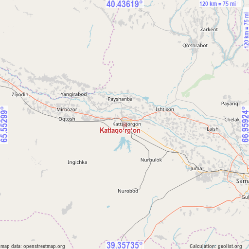
| Upper-left | 40.43619°, | 65.55299° |
| Center: | 39.89889°, | 66.25611° |
| Lower-right: | 39.35735°, | 66.95924° |
| Map W x H: | 120×120 km | = 74.6×74.6mi |
| max Lat: | 43.77877° ⇑76.4% North |
| Kattaqo‘rg‘on: | 39.89889° |
| min Lat: | ⇓23.6% South 37.22417° |
| min Long | Kattaqo‘rg‘ | max Long |
| 58.84596° | 66.25611° | 72.76177° |
| W 38.5%⇐ | ⇒61.5% E |
Elevation
Elevation of Kattaqo‘rg‘on is 486 m = 1594 ft, and this is 52.2 m = 171 ft above average elevation for this country.
| Max E: |
1464 m = 4803 ft | 37.4% |
| Kattaqo‘rg‘on | 486 m 1594 ft | |
| Avg. | 433.8 m = 1423 ft | |
Min E: |
50 m = 164 ft | 62.6% |
See also: Kattaqo‘rg‘on elevation on elevation.city.
Geographical zone
Kattaqo‘rg‘on is located in North temperate zone (between Tropic of Cancer and the Arctic Circle). Distance of this Northern Tropic circle is 1830.4 km =1137.4 mi to South.| Distance of | km | miles | from Kattaqo‘rg‘on |
|---|---|---|---|
| North Pole | 5570.7 | 3461.5 | to North |
| Arctic Circle | 2964.8 | 1842.2 | to North |
| Tropic Cancer | 1830.4 | 1137.4 | to South |
| Equator | 4436.3 | 2756.6 | to South |


Nearby cities:
15 places around Kattaqo‘rg‘on: (largest is in red/bold)
• Beshrabot
85.1 km =52.9 mi,  292°
292°
• Bulung’ur
88 km =54.7 mi,  99°
99°
• Charxin
49.2 km =30.6 mi,  117°
117°
• Chelak
51.7 km =32.1 mi,  87°
87°
• Daxbet
58 km =36 mi, 104°
• Ishtixon
21 km =13 mi,  69°
69°
• Jomboy
74.9 km =46.5 mi,  107°
107°
• Juma
40.3 km =25 mi, 120°
• Karmana Shahri
79.6 km =49.5 mi, 289°
• Navoiy
77.5 km =48.2 mi, 285°
• Nurota
88 km =54.7 mi,  326°
326°
• Oqtosh
28.3 km =17.6 mi,  275°
275°
• Payshanba
12.2 km =7.6 mi,  352°
352°
• Samarkand
66 km =41 mi, 114°
• Yangirabot
28.8 km =17.9 mi,  299°
299°
Sources, notices
• [Note1] Compared only with cities in Uzbekistan existing in our database
• [Src1] Map data: © OpenStreetMap contributors (CC-BY-SA)
• [Src2] Other city data from geonames.org with taken over terms of usage.
• [Src3] Geographical zone / Annual Mean Temperature by Robert A. Rohde @ Wikipedia
