Yangiobod geodata
Yangiobod (Toshkent) is a populated place; located in Uzbekistan in Asia/Tashkent (GMT+5) time zone. With population of 24,900 people, there are 69 cities with bigger population in this country. Compared to other cities in Uzbekistan, 74.7% of cities are located further ↓South; 69% of cities are located further ←West and 98.9% of cities have lower elevation than Yangiobod. Note1


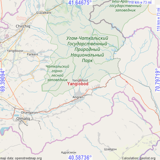
Yangiobod GPS coordinates[2]
41° 7' 9.084" North, 70° 5' 38.616" East
| Map corner | latitude | longitude |
|---|---|---|
| Upper-left | 41.64675°, | 69.39094° |
| Center: | 41.11919°, | 70.09406° |
| Lower-right: | 40.58736°, | 70.79719° |
| Map W x H: | 117.8×117.8 km | = 73.2×73.2mi |
| max Lat: | 43.77877° ⇑25.3% North |
| Yangiobod: | 41.11919° |
| min Lat: | ⇓74.7% South 37.22417° |
| min Long | Yangiobod | max Long |
| 58.84596° | 70.09406° | 72.76177° |
| W 69%⇐ | ⇒31% E |
Elevation
Elevation of Yangiobod is 1310 m = 4298 ft, and this is 876.2 m = 2875 ft above average elevation for this country.
| Max E: |
1464 m = 4803 ft | 1.1% |
| Yangiobod | 1310 m 4298 ft | |
| Avg. | 433.8 m = 1423 ft | |
Min E: |
50 m = 164 ft | 98.9% |
See also: Uzbekistan elevation on elevation.city.
Geographical zone
Yangiobod is located in North temperate zone (between Tropic of Cancer and the Arctic Circle). Distance of this Northern Tropic circle is 1966.1 km =1221.7 mi to South.| Distance of | km | miles | from Yangiobod |
|---|---|---|---|
| North Pole | 5435 | 3377.2 | to North |
| Arctic Circle | 2829.1 | 1757.9 | to North |
| Tropic Cancer | 1966.1 | 1221.7 | to South |
| Equator | 4572 | 2840.9 | to South |


Nearby cities:
15 places around Yangiobod: (largest is in red/bold)
• Angren
12.1 km =7.5 mi,  159°
159°
• Bektemir
64.4 km =40 mi,  278°
278°
• Chirchiq
57.8 km =35.9 mi,  312°
312°
• G‘azalkent
55.8 km =34.7 mi,  331°
331°
• Iskandar
58.4 km =36.3 mi, 325°
• Kyzyldzhar
50.2 km =31.2 mi,  352°
352°
• Ohangaron
45 km =28 mi,  238°
238°
• Olmaliq
51.6 km =32.1 mi,  233°
233°
• Parkent
40 km =24.9 mi,  299°
299°
• Piskent
67.1 km =41.7 mi,  248°
248°
• Qibray
60.6 km =37.7 mi, 299°
• Salor
65.9 km =40.9 mi, 295°
• Sŭqoq
28.7 km =17.8 mi, 300°
• Tashkent
75.2 km =46.7 mi, 282°
• Tŭytepa
62.1 km =38.6 mi,  261°
261°
Sources, notices
• [Note1] Compared only with cities in Uzbekistan existing in our database
• [Src1] Map data: © OpenStreetMap contributors (CC-BY-SA)
• [Src2] Other city data from geonames.org with taken over terms of usage.
• [Src3] Geographical zone / Annual Mean Temperature by Robert A. Rohde @ Wikipedia
