Karmana Shahri geodata
Karmana Shahri (Navoiy) is a seat of a second-order administrative division; located in Uzbekistan in Asia/Samarkand (GMT+5) time zone. In our database, there are 114 cities with bigger population. Compared to other cities in Uzbekistan, 65.5% of cities are located further ↑North; 71.3% of cities are located further →East and 61.5% of cities have higher elevation than Karmana Shahri. Note1


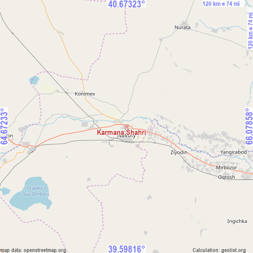
Karmana Shahri GPS coordinates[2]
40° 8' 16.152" North, 65° 22' 31.62" East
| Map corner | latitude | longitude |
|---|---|---|
| Upper-left | 40.67323°, | 64.67233° |
| Center: | 40.13782°, | 65.37545° |
| Lower-right: | 39.59816°, | 66.07858° |
| Map W x H: | 119.5×119.5 km | = 74.3×74.3mi |
| max Lat: | 43.77877° ⇑65.5% North |
| Karmana Shahri: | 40.13782° |
| min Lat: | ⇓34.5% South 37.22417° |
| min Long | Karmana Shahri | max Long |
| 58.84596° | 65.37545° | 72.76177° |
| W 28.7%⇐ | ⇒71.3% E |
Elevation
Elevation of Karmana Shahri is 350 m = 1148 ft, and this is 83.8 m = 275 ft below average elevation for this country.
| Max E: |
1464 m = 4803 ft | 61.5% |
| Avg. | 433.8 m = 1423 ft | |
| Karmana Shahri | 350 m = 1148 ft | |
Min E: |
50 m = 164 ft | 38.5% |
See also: Uzbekistan elevation on elevation.city.
Geographical zone
Karmana Shahri is located in North temperate zone (between Tropic of Cancer and the Arctic Circle). Distance of this Northern Tropic circle is 1857 km =1153.9 mi to South.| Distance of | km | miles | from Karmana Shahri |
|---|---|---|---|
| North Pole | 5544.2 | 3445 | to North |
| Arctic Circle | 2938.3 | 1825.8 | to North |
| Tropic Cancer | 1857 | 1153.9 | to South |
| Equator | 4462.9 | 2773.1 | to South |


Nearby cities:
15 places around Karmana Shahri: (largest is in red/bold)
• Beshrabot
7.5 km =4.7 mi,  332°
332°
• Ghijduwon
59 km =36.7 mi,  265°
265°
• Kattaqo‘rg‘on
79.6 km =49.5 mi,  109°
109°
• Kogon
84 km =52.2 mi,  236°
236°
• Konimex
24.9 km =15.5 mi,  308°
308°
• Navoiy
5.9 km =3.7 mi,  176°
176°
• Nurota
54.1 km =33.6 mi,  29°
29°
• Nurota Shahri
54.3 km =33.7 mi, 28°
• Oqtosh
52.6 km =32.7 mi,  117°
117°
• Payshanba
74.7 km =46.4 mi,  101°
101°
• Qiziltepa
46.2 km =28.7 mi,  255°
255°
• Qiziltepa Shahri
48.2 km =30 mi,  254°
254°
• Shofirkon
74.3 km =46.2 mi, 268°
• Wobkent
74.2 km =46.1 mi, 260°
• Yangirabot
51.4 km =31.9 mi, 104°
Sources, notices
• [Note1] Compared only with cities in Uzbekistan existing in our database
• [Src1] Map data: © OpenStreetMap contributors (CC-BY-SA)
• [Src2] Other city data from geonames.org with taken over terms of usage.
• [Src3] Geographical zone / Annual Mean Temperature by Robert A. Rohde @ Wikipedia
