Gagarin geodata
Gagarin (Jizzax) is a populated place; located in Uzbekistan in Asia/Tashkent (GMT+5) time zone. With population of 24,856 people, there are 71 cities with bigger population in this country. Compared to other cities in Uzbekistan, 54.6% of cities are located further ↓South; 53.4% of cities are located further ←West and 73.6% of cities have higher elevation than Gagarin. Note1


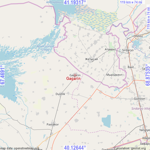
Gagarin GPS coordinates[2]
40° 39' 42.984" North, 68° 10' 19.992" East
| Map corner | latitude | longitude |
|---|---|---|
| Upper-left | 41.19317°, | 67.4691° |
| Center: | 40.66194°, | 68.17222° |
| Lower-right: | 40.12644°, | 68.87535° |
| Map W x H: | 118.6×118.6 km | = 73.7×73.7mi |
| max Lat: | 43.77877° ⇑45.4% North |
| Gagarin: | 40.66194° |
| min Lat: | ⇓54.6% South 37.22417° |
| min Long | Gagarin | max Long |
| 58.84596° | 68.17222° | 72.76177° |
| W 53.4%⇐ | ⇒46.6% E |
Elevation
Elevation of Gagarin is 267 m = 876 ft, and this is 166.8 m = 547 ft below average elevation for this country.
| Max E: |
1464 m = 4803 ft | 73.6% |
| Avg. | 433.8 m = 1423 ft | |
| Gagarin | 267 m = 876 ft | |
Min E: |
50 m = 164 ft | 26.4% |
See also: Uzbekistan elevation on elevation.city.
Geographical zone
Gagarin is located in North temperate zone (between Tropic of Cancer and the Arctic Circle). Distance of this Northern Tropic circle is 1915.3 km =1190.1 mi to South.| Distance of | km | miles | from Gagarin |
|---|---|---|---|
| North Pole | 5485.9 | 3408.8 | to North |
| Arctic Circle | 2880 | 1789.5 | to North |
| Tropic Cancer | 1915.3 | 1190.1 | to South |
| Equator | 4521.2 | 2809.3 | to South |


Nearby cities:
15 places around Gagarin: (largest is in red/bold)
• Amir Timur
75.9 km =47.2 mi,  58°
58°
• Bo‘ka
87.7 km =54.5 mi,  79°
79°
• Chinoz
58.2 km =36.2 mi, 58°
• Dashtobod
65.4 km =40.6 mi,  155°
155°
• Dŭstlik
19.1 km =11.9 mi,  217°
217°
• Guliston
55.1 km =34.2 mi,  110°
110°
• Jizzax
66.8 km =41.5 mi,  204°
204°
• Paxtakor
42.7 km =26.5 mi,  205°
205°
• Piskent
102.6 km =63.8 mi, 75°
• Sirdaryo
45.9 km =28.5 mi, 63°
• Yangiyer
69.8 km =43.4 mi,  128°
128°
• Yangiyŭl
89 km =55.3 mi, 55°
• Zafar
70.9 km =44.1 mi, 59°
• Zomin
80.3 km =49.9 mi,  166°
166°
• Ŭrtaowul
100.4 km =62.4 mi,  54°
54°
Sources, notices
• [Note1] Compared only with cities in Uzbekistan existing in our database
• [Src1] Map data: © OpenStreetMap contributors (CC-BY-SA)
• [Src2] Other city data from geonames.org with taken over terms of usage.
• [Src3] Geographical zone / Annual Mean Temperature by Robert A. Rohde @ Wikipedia
