Paxtakor geodata
Paxtakor (Jizzax) is a populated place; located in Uzbekistan in Asia/Samarkand (GMT+5) time zone. With population of 21,384 people, there are 79 cities with bigger population in this country. Compared to other cities in Uzbekistan, 61.5% of cities are located further ↑North; 52.3% of cities are located further ←West and 69% of cities have higher elevation than Paxtakor. Note1


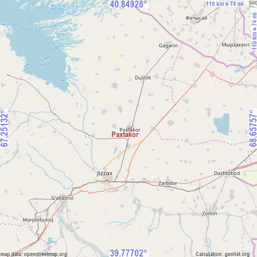
Paxtakor GPS coordinates[2]
40° 18' 55.008" North, 67° 57' 15.984" East
| Map corner | latitude | longitude |
|---|---|---|
| Upper-left | 40.84928°, | 67.25132° |
| Center: | 40.31528°, | 67.95444° |
| Lower-right: | 39.77702°, | 68.65757° |
| Map W x H: | 119.2×119.2 km | = 74.1×74.1mi |
| max Lat: | 43.77877° ⇑61.5% North |
| Paxtakor: | 40.31528° |
| min Lat: | ⇓38.5% South 37.22417° |
| min Long | Paxtakor | max Long |
| 58.84596° | 67.95444° | 72.76177° |
| W 52.3%⇐ | ⇒47.7% E |
Elevation
Elevation of Paxtakor is 307 m = 1007 ft, and this is 126.8 m = 416 ft below average elevation for this country.
| Max E: |
1464 m = 4803 ft | 69% |
| Avg. | 433.8 m = 1423 ft | |
| Paxtakor | 307 m = 1007 ft | |
Min E: |
50 m = 164 ft | 31% |
See also: Uzbekistan elevation on elevation.city.
Geographical zone
Paxtakor is located in North temperate zone (between Tropic of Cancer and the Arctic Circle). Distance of this Northern Tropic circle is 1876.7 km =1166.1 mi to South.| Distance of | km | miles | from Paxtakor |
|---|---|---|---|
| North Pole | 5524.4 | 3432.7 | to North |
| Arctic Circle | 2918.5 | 1813.5 | to North |
| Tropic Cancer | 1876.7 | 1166.1 | to South |
| Equator | 4482.6 | 2785.4 | to South |


Nearby cities:
15 places around Paxtakor: (largest is in red/bold)
• Bekobod
112.1 km =69.7 mi,  95°
95°
• Bulung’ur
84.4 km =52.4 mi,  223°
223°
• Chelak
102.8 km =63.9 mi,  244°
244°
• Chinoz
97 km =60.3 mi,  44°
44°
• Dashtobod
50.4 km =31.3 mi,  114°
114°
• Daxbet
107.8 km =67 mi, 235°
• Dŭstlik
24.3 km =15.1 mi,  16°
16°
• Gagarin
42.7 km =26.5 mi,  25°
25°
• Guliston
72.9 km =45.3 mi,  74°
74°
• Jizzax
24.1 km =15 mi,  203°
203°
• Jomboy
100.4 km =62.4 mi,  226°
226°
• Sirdaryo
83.8 km =52.1 mi,  45°
45°
• Yangiyer
73.8 km =45.9 mi,  93°
93°
• Zafar
109 km =67.7 mi, 47°
• Zomin
54.4 km =33.8 mi,  136°
136°
Sources, notices
• [Note1] Compared only with cities in Uzbekistan existing in our database
• [Src1] Map data: © OpenStreetMap contributors (CC-BY-SA)
• [Src2] Other city data from geonames.org with taken over terms of usage.
• [Src3] Geographical zone / Annual Mean Temperature by Robert A. Rohde @ Wikipedia
