Yangiyer geodata
Yangiyer (Sirdaryo) is a populated place; located in Uzbekistan in Asia/Tashkent (GMT+5) time zone. With population of 32,636 people, there are 42 cities with bigger population in this country. Compared to other cities in Uzbekistan, 63.2% of cities are located further ↑North; 56.9% of cities are located further ←West and 67.2% of cities have higher elevation than Yangiyer. Note1


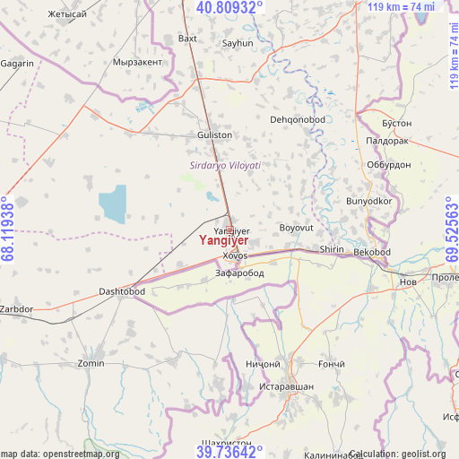
Yangiyer GPS coordinates[2]
40° 16' 30" North, 68° 49' 21" East
| Map corner | latitude | longitude |
|---|---|---|
| Upper-left | 40.80932°, | 68.11938° |
| Center: | 40.275°, | 68.8225° |
| Lower-right: | 39.73642°, | 69.52563° |
| Map W x H: | 119.3×119.3 km | = 74.1×74.1mi |
| max Lat: | 43.77877° ⇑63.2% North |
| Yangiyer: | 40.275° |
| min Lat: | ⇓36.8% South 37.22417° |
| min Long | Yangiyer | max Long |
| 58.84596° | 68.8225° | 72.76177° |
| W 56.9%⇐ | ⇒43.1% E |
Elevation
Elevation of Yangiyer is 314 m = 1030 ft, and this is 119.8 m = 393 ft below average elevation for this country.
| Max E: |
1464 m = 4803 ft | 67.2% |
| Avg. | 433.8 m = 1423 ft | |
| Yangiyer | 314 m = 1030 ft | |
Min E: |
50 m = 164 ft | 32.8% |
See also: Uzbekistan elevation on elevation.city.
Geographical zone
Yangiyer is located in North temperate zone (between Tropic of Cancer and the Arctic Circle). Distance of this Northern Tropic circle is 1872.2 km =1163.3 mi to South.| Distance of | km | miles | from Yangiyer |
|---|---|---|---|
| North Pole | 5528.9 | 3435.5 | to North |
| Arctic Circle | 2923 | 1816.3 | to North |
| Tropic Cancer | 1872.2 | 1163.3 | to South |
| Equator | 4478.2 | 2782.6 | to South |


Nearby cities:
15 places around Yangiyer: (largest is in red/bold)
• Amir Timur
83.4 km =51.8 mi,  6°
6°
• Bekobod
38.4 km =23.9 mi,  99°
99°
• Bo‘ka
67.4 km =41.9 mi,  27°
27°
• Chinoz
73.7 km =45.8 mi,  355°
355°
• Dashtobod
32.4 km =20.1 mi,  239°
239°
• Dŭstlik
72.2 km =44.9 mi,  292°
292°
• Gagarin
69.8 km =43.4 mi,  308°
308°
• Guliston
24.1 km =15 mi,  352°
352°
• Jizzax
85.1 km =52.9 mi,  257°
257°
• Olmaliq
91.1 km =56.6 mi,  45°
45°
• Paxtakor
73.8 km =45.9 mi,  273°
273°
• Piskent
82.3 km =51.1 mi, 32°
• Sirdaryo
64.7 km =40.2 mi, 347°
• Zafar
79 km =49.1 mi,  4°
4°
• Zomin
50.4 km =31.3 mi,  226°
226°
Sources, notices
• [Note1] Compared only with cities in Uzbekistan existing in our database
• [Src1] Map data: © OpenStreetMap contributors (CC-BY-SA)
• [Src2] Other city data from geonames.org with taken over terms of usage.
• [Src3] Geographical zone / Annual Mean Temperature by Robert A. Rohde @ Wikipedia
