Dŭstlik geodata
Dŭstlik (Jizzax) is a populated place; located in Uzbekistan in Asia/Tashkent (GMT+5) time zone. With population of 16,524 people, there are 93 cities with bigger population in this country. Compared to other cities in Uzbekistan, 51.1% of cities are located further ↑North; 52.9% of cities are located further ←West and 73% of cities have higher elevation than Dŭstlik. Note1


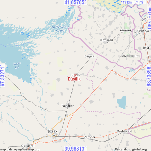
Dŭstlik GPS coordinates[2]
40° 31' 28.992" North, 68° 2' 8.988" East
| Map corner | latitude | longitude |
|---|---|---|
| Upper-left | 41.05705°, | 67.33271° |
| Center: | 40.52472°, | 68.03583° |
| Lower-right: | 39.98813°, | 68.73896° |
| Map W x H: | 118.9×118.9 km | = 73.9×73.9mi |
| max Lat: | 43.77877° ⇑51.1% North |
| Dŭstlik: | 40.52472° |
| min Lat: | ⇓48.9% South 37.22417° |
| min Long | Dŭstlik | max Long |
| 58.84596° | 68.03583° | 72.76177° |
| W 52.9%⇐ | ⇒47.1% E |
Elevation
Elevation of Dŭstlik is 273 m = 896 ft, and this is 160.8 m = 528 ft below average elevation for this country.
| Max E: |
1464 m = 4803 ft | 73% |
| Avg. | 433.8 m = 1423 ft | |
| Dŭstlik | 273 m = 896 ft | |
Min E: |
50 m = 164 ft | 27% |
See also: Uzbekistan elevation on elevation.city.
Geographical zone
Dŭstlik is located in North temperate zone (between Tropic of Cancer and the Arctic Circle). Distance of this Northern Tropic circle is 1900 km =1180.6 mi to South.| Distance of | km | miles | from Dŭstlik |
|---|---|---|---|
| North Pole | 5501.1 | 3418.2 | to North |
| Arctic Circle | 2895.2 | 1799 | to North |
| Tropic Cancer | 1900 | 1180.6 | to South |
| Equator | 4505.9 | 2799.8 | to South |


Nearby cities:
15 places around Dŭstlik: (largest is in red/bold)
• Amir Timur
94 km =58.4 mi,  54°
54°
• Bekobod
109.8 km =68.2 mi,  107°
107°
• Bo‘ka
102.7 km =63.8 mi,  71°
71°
• Bulung’ur
106.6 km =66.2 mi,  217°
217°
• Chinoz
76.4 km =47.5 mi, 53°
• Dashtobod
58.9 km =36.6 mi,  138°
138°
• Gagarin
19.1 km =11.9 mi,  37°
37°
• Guliston
63.4 km =39.4 mi,  93°
93°
• Jizzax
48.3 km =30 mi,  199°
199°
• Paxtakor
24.3 km =15.1 mi, 196°
• Sirdaryo
63.6 km =39.5 mi,  56°
56°
• Yangiyer
72.2 km =44.9 mi, 112°
• Yangiyŭl
107.3 km =66.7 mi, 52°
• Zafar
88.9 km =55.2 mi, 54°
• Zomin
69.8 km =43.4 mi,  154°
154°
Sources, notices
• [Note1] Compared only with cities in Uzbekistan existing in our database
• [Src1] Map data: © OpenStreetMap contributors (CC-BY-SA)
• [Src2] Other city data from geonames.org with taken over terms of usage.
• [Src3] Geographical zone / Annual Mean Temperature by Robert A. Rohde @ Wikipedia
