Jizzax geodata
Jizzax is a seat of a first-order administrative division; located in Uzbekistan in Asia/Samarkand (GMT+5) time zone. With population of 152,642 people, there are 10 cities with bigger population in this country. Compared to other cities in Uzbekistan, 67.8% of cities are located further ↑North; 51.1% of cities are located further ←West and 59.2% of cities have higher elevation than Jizzax. Note1


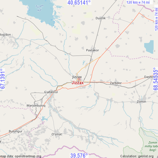
Jizzax GPS coordinates[2]
40° 6' 56.988" North, 67° 50' 31.992" East
| Map corner | latitude | longitude |
|---|---|---|
| Upper-left | 40.65141°, | 67.1391° |
| Center: | 40.11583°, | 67.84222° |
| Lower-right: | 39.576°, | 68.54535° |
| Map W x H: | 119.6×119.6 km | = 74.3×74.3mi |
| max Lat: | 43.77877° ⇑67.8% North |
| Jizzax: | 40.11583° |
| min Lat: | ⇓32.2% South 37.22417° |
| min Long | Jizzax | max Long |
| 58.84596° | 67.84222° | 72.76177° |
| W 51.1%⇐ | ⇒48.9% E |
Elevation
Elevation of Jizzax is 382 m = 1253 ft, and this is 51.8 m = 170 ft below average elevation for this country.
| Max E: |
1464 m = 4803 ft | 59.2% |
| Avg. | 433.8 m = 1423 ft | |
| Jizzax | 382 m = 1253 ft | |
Min E: |
50 m = 164 ft | 40.8% |
See also: Jizzax elevation on elevation.city.
Geographical zone
Jizzax is located in North temperate zone (between Tropic of Cancer and the Arctic Circle). Distance of this Northern Tropic circle is 1854.5 km =1152.3 mi to South.| Distance of | km | miles | from Jizzax |
|---|---|---|---|
| North Pole | 5546.6 | 3446.5 | to North |
| Arctic Circle | 2940.7 | 1827.3 | to North |
| Tropic Cancer | 1854.5 | 1152.3 | to South |
| Equator | 4460.5 | 2771.6 | to South |


Nearby cities:
15 places around Jizzax: (largest is in red/bold)
• Bulung’ur
62.4 km =38.8 mi,  231°
231°
• Charxin
102.7 km =63.8 mi,  243°
243°
• Chelak
86.3 km =53.6 mi,  255°
255°
• Dashtobod
55.5 km =34.5 mi,  88°
88°
• Daxbet
88.4 km =54.9 mi, 243°
• Dŭstlik
48.3 km =30 mi,  19°
19°
• Gagarin
66.8 km =41.5 mi, 24°
• Guliston
90 km =55.9 mi,  62°
62°
• Jomboy
78.9 km =49 mi, 234°
• Paxtakor
24.1 km =15 mi, 23°
• Samarkand
91.1 km =56.6 mi, 235°
• Sirdaryo
106.5 km =66.2 mi,  40°
40°
• Urgut
94.4 km =58.7 mi,  212°
212°
• Yangiyer
85.1 km =52.9 mi,  77°
77°
• Zomin
50.2 km =31.2 mi,  110°
110°
Sources, notices
• [Note1] Compared only with cities in Uzbekistan existing in our database
• [Src1] Map data: © OpenStreetMap contributors (CC-BY-SA)
• [Src2] Other city data from geonames.org with taken over terms of usage.
• [Src3] Geographical zone / Annual Mean Temperature by Robert A. Rohde @ Wikipedia
