Zomin geodata
Zomin (Jizzax) is a populated place; located in Uzbekistan in Asia/Samarkand (GMT+5) time zone. With population of 27,077 people, there are 55 cities with bigger population in this country. Compared to other cities in Uzbekistan, 74.1% of cities are located further ↑North; 54% of cities are located further ←West and 85.1% of cities have lower elevation than Zomin. Note1


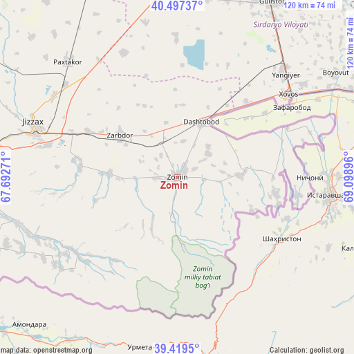
Zomin GPS coordinates[2]
39° 57' 38.016" North, 68° 23' 44.988" East
| Map corner | latitude | longitude |
|---|---|---|
| Upper-left | 40.49737°, | 67.69271° |
| Center: | 39.96056°, | 68.39583° |
| Lower-right: | 39.4195°, | 69.09896° |
| Map W x H: | 119.8×119.8 km | = 74.4×74.4mi |
| max Lat: | 43.77877° ⇑74.1% North |
| Zomin: | 39.96056° |
| min Lat: | ⇓25.9% South 37.22417° |
| min Long | Zomin | max Long |
| 58.84596° | 68.39583° | 72.76177° |
| W 54%⇐ | ⇒46% E |
Elevation
Elevation of Zomin is 645 m = 2116 ft, and this is 211.2 m = 693 ft above average elevation for this country.
| Max E: |
1464 m = 4803 ft | 14.9% |
| Zomin | 645 m 2116 ft | |
| Avg. | 433.8 m = 1423 ft | |
Min E: |
50 m = 164 ft | 85.1% |
See also: Uzbekistan elevation on elevation.city.
Geographical zone
Zomin is located in North temperate zone (between Tropic of Cancer and the Arctic Circle). Distance of this Northern Tropic circle is 1837.3 km =1141.6 mi to South.| Distance of | km | miles | from Zomin |
|---|---|---|---|
| North Pole | 5563.9 | 3457.2 | to North |
| Arctic Circle | 2958 | 1838 | to North |
| Tropic Cancer | 1837.3 | 1141.6 | to South |
| Equator | 4443.2 | 2760.9 | to South |


Nearby cities:
15 places around Zomin: (largest is in red/bold)
• Bekobod
79.8 km =49.6 mi,  68°
68°
• Bo‘ka
116.3 km =72.3 mi,  35°
35°
• Bulung’ur
98.4 km =61.1 mi,  257°
257°
• Chinoz
112.8 km =70.1 mi,  15°
15°
• Dashtobod
20.3 km =12.6 mi, 24°
• Dŭstlik
69.8 km =43.4 mi,  334°
334°
• Gagarin
80.3 km =49.9 mi,  346°
346°
• Guliston
67.4 km =41.9 mi,  29°
29°
• Jizzax
50.2 km =31.2 mi,  290°
290°
• Jomboy
115 km =71.5 mi, 255°
• Paxtakor
54.4 km =33.8 mi,  316°
316°
• Sirdaryo
100.7 km =62.6 mi,  12°
12°
• Urgut
116.6 km =72.5 mi,  237°
237°
• Yangiyer
50.4 km =31.3 mi,  46°
46°
• Zafar
121.5 km =75.5 mi, 20°
Sources, notices
• [Note1] Compared only with cities in Uzbekistan existing in our database
• [Src1] Map data: © OpenStreetMap contributors (CC-BY-SA)
• [Src2] Other city data from geonames.org with taken over terms of usage.
• [Src3] Geographical zone / Annual Mean Temperature by Robert A. Rohde @ Wikipedia
