Bekobod geodata
Bekobod (Toshkent) is a populated place; located in Uzbekistan in Asia/Tashkent (GMT+5) time zone. With population of 86,259 people, there are 17 cities with bigger population in this country. Compared to other cities in Uzbekistan, 63.8% of cities are located further ↑North; 60.9% of cities are located further ←West and 70.1% of cities have higher elevation than Bekobod. Note1


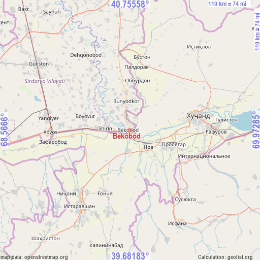
Bekobod GPS coordinates[2]
40° 13' 14.988" North, 69° 16' 10.992" East
| Map corner | latitude | longitude |
|---|---|---|
| Upper-left | 40.75558°, | 68.5666° |
| Center: | 40.22083°, | 69.26972° |
| Lower-right: | 39.68183°, | 69.97285° |
| Map W x H: | 119.4×119.4 km | = 74.2×74.2mi |
| max Lat: | 43.77877° ⇑63.8% North |
| Bekobod: | 40.22083° |
| min Lat: | ⇓36.2% South 37.22417° |
| min Long | Bekobod | max Long |
| 58.84596° | 69.26972° | 72.76177° |
| W 60.9%⇐ | ⇒39.1% E |
Elevation
Elevation of Bekobod is 303 m = 994 ft, and this is 130.8 m = 429 ft below average elevation for this country.
| Max E: |
1464 m = 4803 ft | 70.1% |
| Avg. | 433.8 m = 1423 ft | |
| Bekobod | 303 m = 994 ft | |
Min E: |
50 m = 164 ft | 29.9% |
See also: Bekobod elevation on elevation.city.
Geographical zone
Bekobod is located in North temperate zone (between Tropic of Cancer and the Arctic Circle). Distance of this Northern Tropic circle is 1866.2 km =1159.6 mi to South.| Distance of | km | miles | from Bekobod |
|---|---|---|---|
| North Pole | 5534.9 | 3439.2 | to North |
| Arctic Circle | 2929 | 1820 | to North |
| Tropic Cancer | 1866.2 | 1159.6 | to South |
| Equator | 4472.1 | 2778.8 | to South |


Nearby cities:
15 places around Bekobod: (largest is in red/bold)
• Amir Timur
93 km =57.8 mi,  342°
342°
• Bo‘ka
65.9 km =40.9 mi,  354°
354°
• Chinoz
90.4 km =56.2 mi,  331°
331°
• Dashtobod
66.7 km =41.4 mi,  260°
260°
• Gagarin
105 km =65.2 mi,  297°
297°
• Guliston
50.9 km =31.6 mi,  306°
306°
• Ohangaron
82.3 km =51.1 mi,  22°
22°
• Olmaliq
74.7 km =46.4 mi, 21°
• Piskent
75.5 km =46.9 mi,  5°
5°
• Sirdaryo
86.2 km =53.6 mi,  323°
323°
• Tŭytepa
90.5 km =56.2 mi,  4°
4°
• Yangiyer
38.4 km =23.9 mi,  279°
279°
• Yangiyŭl
100.9 km =62.7 mi, 349°
• Zafar
90.3 km =56.1 mi, 339°
• Zomin
79.8 km =49.6 mi,  248°
248°
Sources, notices
• [Note1] Compared only with cities in Uzbekistan existing in our database
• [Src1] Map data: © OpenStreetMap contributors (CC-BY-SA)
• [Src2] Other city data from geonames.org with taken over terms of usage.
• [Src3] Geographical zone / Annual Mean Temperature by Robert A. Rohde @ Wikipedia
