San Rafael de Onoto geodata
San Rafael de Onoto (Portuguesa) is a seat of a second-order administrative division; located in Venezuela in America/Caracas (GMT-4) time zone. In our database, there are 108 cities with bigger population. Compared to other cities in Venezuela, 52.2% of cities are located further ↓South; 51.7% of cities are located further →East and 57.3% of cities have higher elevation than San Rafael de Onoto. Note1


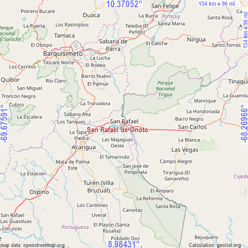
San Rafael de Onoto GPS coordinates[2]
9° 40' 41.268" North, 68° 58' 22.008" West
| Map corner | latitude | longitude |
|---|---|---|
| Upper-left | 10.37052°, | -69.67591° |
| Center: | 9.67813°, | -68.97278° |
| Lower-right: | 8.98431°, | -68.26966° |
| Map W x H: | 154.1×154.1 km | = 95.8×95.8mi |
| max Lat: | 11.94788° ⇑47.8% North |
| San Rafael de Onoto: | 9.67813° |
| min Lat: | ⇓52.2% South 1.92027° |
| min Long | San Rafael de O | max Long |
| -72.55212° | -68.97278° | -60.99778° |
| W 48.3%⇐ | ⇒51.7% E |
Elevation
Elevation of San Rafael de Onoto is 152 m = 499 ft, and this is 228.6 m = 750 ft below average elevation for this country.
| Max E: |
2986 m = 9797 ft | 57.3% |
| Avg. | 380.6 m = 1249 ft | |
| San Rafael de Onoto | 152 m = 499 ft | |
Min E: |
-4 m = -13 ft | 42.7% |
See also: Venezuela elevation on elevation.city.
Geographical zone
San Rafael de Onoto is located in North Torrid zone (between Equator and Tropic of Cancer). Distance of Equator is 1076.1 km =668.7 mi to South.| Distance of | km | miles | from San Rafael de Onoto |
|---|---|---|---|
| North Pole | 8931 | 5549.5 | to North |
| Arctic Circle | 6325.1 | 3930.2 | to North |
| Tropic Cancer | 1529.8 | 950.6 | to North |
| Equator | 1076.1 | 668.7 | to South |


Nearby cities:
15 places around San Rafael de Onoto: (largest is in red/bold)
• Acarigua
28 km =17.4 mi,  240°
240°
• Agua Blanca
14.8 km =9.2 mi,  263°
263°
• Araure
31.1 km =19.3 mi,  249°
249°
• Cabudare
50.1 km =31.1 mi,  320°
320°
• Cojedes
8.6 km =5.3 mi,  135°
135°
• Las Vegas
40.7 km =25.3 mi,  112°
112°
• Libertad
47.2 km =29.3 mi, 139°
• Los Rastrojos
48.6 km =30.2 mi, 322°
• Píritu
43 km =26.7 mi,  217°
217°
• Sabana de Parra
49.7 km =30.9 mi,  351°
351°
• San Carlos
42.8 km =26.6 mi,  92°
92°
• Sarare
23.8 km =14.8 mi,  298°
298°
• Urachiche
53.5 km =33.2 mi,  355°
355°
• Villa Bruzual
41.7 km =25.9 mi,  202°
202°
• Yaritagua
47.7 km =29.6 mi,  339°
339°
Sources, notices
• [Note1] Compared only with cities in Venezuela existing in our database
• [Src1] Map data: © OpenStreetMap contributors (CC-BY-SA)
• [Src2] Other city data from geonames.org with taken over terms of usage.
• [Src3] Geographical zone / Annual Mean Temperature by Robert A. Rohde @ Wikipedia
