Cojedes geodata
Cojedes is a seat of a second-order administrative division; located in Venezuela in America/Caracas (GMT-4) time zone. In our database, there are 108 cities with bigger population. Compared to other cities in Venezuela, 50.6% of cities are located further ↓South; 51.4% of cities are located further →East and 57.8% of cities have higher elevation than Cojedes. Note1


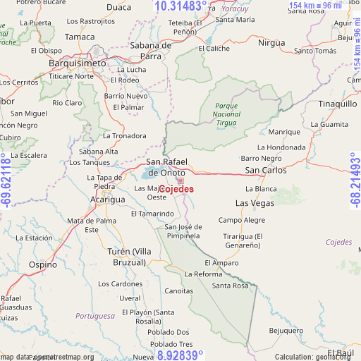
Cojedes GPS coordinates[2]
9° 37' 20.352" North, 68° 55' 4.98" West
| Map corner | latitude | longitude |
|---|---|---|
| Upper-left | 10.31483°, | -69.62118° |
| Center: | 9.62232°, | -68.91805° |
| Lower-right: | 8.92839°, | -68.21493° |
| Map W x H: | 154.2×154.2 km | = 95.8×95.8mi |
| max Lat: | 11.94788° ⇑49.4% North |
| Cojedes: | 9.62232° |
| min Lat: | ⇓50.6% South 1.92027° |
| min Long | Cojedes | max Long |
| -72.55212° | -68.91805° | -60.99778° |
| W 48.6%⇐ | ⇒51.4% E |
Elevation
Elevation of Cojedes is 147 m = 482 ft, and this is 233.6 m = 766 ft below average elevation for this country.
| Max E: |
2986 m = 9797 ft | 57.8% |
| Avg. | 380.6 m = 1249 ft | |
| Cojedes | 147 m = 482 ft | |
Min E: |
-4 m = -13 ft | 42.2% |
See also: Venezuela elevation on elevation.city.
Geographical zone
Cojedes is located in North Torrid zone (between Equator and Tropic of Cancer). Distance of Equator is 1069.9 km =664.8 mi to South.| Distance of | km | miles | from Cojedes |
|---|---|---|---|
| North Pole | 8937.2 | 5553.3 | to North |
| Arctic Circle | 6331.3 | 3934.1 | to North |
| Tropic Cancer | 1536 | 954.4 | to North |
| Equator | 1069.9 | 664.8 | to South |


Nearby cities:
15 places around Cojedes: (largest is in red/bold)
• Acarigua
31.4 km =19.5 mi,  256°
256°
• Agua Blanca
21.2 km =13.2 mi,  282°
282°
• Araure
35.4 km =22 mi, 262°
• Las Vegas
32.9 km =20.4 mi,  106°
106°
• Libertad
38.6 km =24 mi,  140°
140°
• Los Rastrojos
57.2 km =35.5 mi,  321°
321°
• Macapo
57.2 km =35.5 mi,  66°
66°
• Píritu
42.5 km =26.4 mi,  228°
228°
• Sabana de Parra
57 km =35.4 mi,  346°
346°
• San Carlos
37 km =23 mi,  83°
83°
• San Rafael de Onoto
8.6 km =5.3 mi, 315°
• Sarare
32.2 km =20 mi,  303°
303°
• Tinaco
53.9 km =33.5 mi, 80°
• Villa Bruzual
39.1 km =24.3 mi,  214°
214°
• Yaritagua
55.8 km =34.7 mi,  336°
336°
Sources, notices
• [Note1] Compared only with cities in Venezuela existing in our database
• [Src1] Map data: © OpenStreetMap contributors (CC-BY-SA)
• [Src2] Other city data from geonames.org with taken over terms of usage.
• [Src3] Geographical zone / Annual Mean Temperature by Robert A. Rohde @ Wikipedia
