Jacura geodata
Jacura (Falcón) is a seat of a second-order administrative division; located in Venezuela in America/Caracas (GMT-4) time zone. In our database, there are 108 cities with bigger population. Compared to other cities in Venezuela, 95.4% of cities are located further ↓South; 50.4% of cities are located further →East and 62.8% of cities have lower elevation than Jacura. Note1


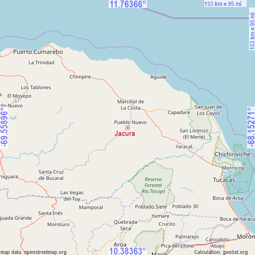
Jacura GPS coordinates[2]
11° 4' 28.056" North, 68° 51' 20.988" West
| Map corner | latitude | longitude |
|---|---|---|
| Upper-left | 11.76366°, | -69.55896° |
| Center: | 11.07446°, | -68.85583° |
| Lower-right: | 10.38363°, | -68.15271° |
| Map W x H: | 153.4×153.4 km | = 95.3×95.3mi |
| max Lat: | 11.94788° ⇑4.6% North |
| Jacura: | 11.07446° |
| min Lat: | ⇓95.4% South 1.92027° |
| min Long | Jacura | max Long |
| -72.55212° | -68.85583° | -60.99778° |
| W 49.6%⇐ | ⇒50.4% E |
Elevation
Elevation of Jacura is 285 m = 935 ft, and this is 95.6 m = 314 ft below average elevation for this country.
| Max E: |
2986 m = 9797 ft | 37.2% |
| Avg. | 380.6 m = 1249 ft | |
| Jacura | 285 m = 935 ft | |
Min E: |
-4 m = -13 ft | 62.8% |
See also: Venezuela elevation on elevation.city.
Geographical zone
Jacura is located in North Torrid zone (between Equator and Tropic of Cancer). Distance of Equator is 1231.4 km =765.2 mi to South.| Distance of | km | miles | from Jacura |
|---|---|---|---|
| North Pole | 8775.7 | 5453 | to North |
| Arctic Circle | 6169.8 | 3833.7 | to North |
| Tropic Cancer | 1374.6 | 854.1 | to North |
| Equator | 1231.4 | 765.2 | to South |


Nearby cities:
15 places around Jacura: (largest is in red/bold)
• Aroa
70.7 km =43.9 mi,  183°
183°
• Chichiriviche
65.7 km =40.8 mi,  104°
104°
• Churuguara
79.9 km =49.6 mi,  248°
248°
• Farriar
74.6 km =46.4 mi,  154°
154°
• Mirimire
17.1 km =10.6 mi,  56°
56°
• Palmasola
63.4 km =39.4 mi, 147°
• Puerto Cumarebo
71 km =44.1 mi,  310°
310°
• Píritu
44.7 km =27.8 mi,  316°
316°
• San Felipe
82.6 km =51.3 mi,  171°
171°
• San Juan de los Cayos
49.5 km =30.8 mi,  77°
77°
• Santa Cruz de Bucaral
54 km =33.6 mi,  238°
238°
• Tocópero
64.5 km =40.1 mi, 317°
• Tucacas
66 km =41 mi,  118°
118°
• Yaracal
35.7 km =22.2 mi,  109°
109°
• Yumare
56.7 km =35.2 mi,  159°
159°
Sources, notices
• [Note1] Compared only with cities in Venezuela existing in our database
• [Src1] Map data: © OpenStreetMap contributors (CC-BY-SA)
• [Src2] Other city data from geonames.org with taken over terms of usage.
• [Src3] Geographical zone / Annual Mean Temperature by Robert A. Rohde @ Wikipedia
