Mirimire geodata
Mirimire (Falcón) is a seat of a second-order administrative division; located in Venezuela in America/Caracas (GMT-4) time zone. In our database, there are 108 cities with bigger population. Compared to other cities in Venezuela, 96.9% of cities are located further ↓South; 51.4% of cities are located further ←West and 53.2% of cities have higher elevation than Mirimire. Note1


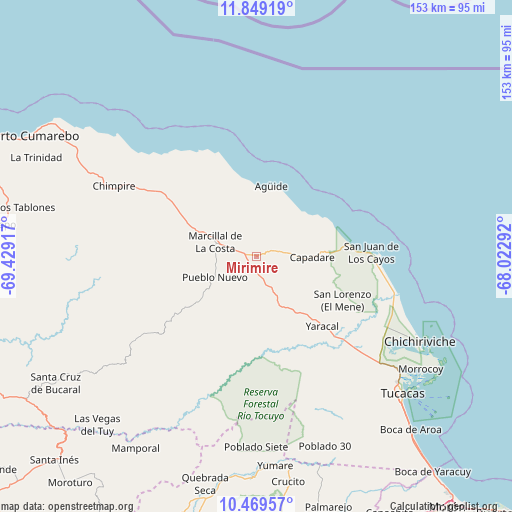
Mirimire GPS coordinates[2]
11° 9' 36.72" North, 68° 43' 33.744" West
| Map corner | latitude | longitude |
|---|---|---|
| Upper-left | 11.84919°, | -69.42917° |
| Center: | 11.1602°, | -68.72604° |
| Lower-right: | 10.46957°, | -68.02292° |
| Map W x H: | 153.4×153.4 km | = 95.3×95.3mi |
| max Lat: | 11.94788° ⇑3.1% North |
| Mirimire: | 11.1602° |
| min Lat: | ⇓96.9% South 1.92027° |
| min Long | Mirimire | max Long |
| -72.55212° | -68.72604° | -60.99778° |
| W 51.4%⇐ | ⇒48.6% E |
Elevation
Elevation of Mirimire is 166 m = 545 ft, and this is 214.6 m = 704 ft below average elevation for this country.
| Max E: |
2986 m = 9797 ft | 53.2% |
| Avg. | 380.6 m = 1249 ft | |
| Mirimire | 166 m = 545 ft | |
Min E: |
-4 m = -13 ft | 46.8% |
See also: Venezuela elevation on elevation.city.
Geographical zone
Mirimire is located in North Torrid zone (between Equator and Tropic of Cancer). Distance of Equator is 1240.9 km =771.1 mi to South.| Distance of | km | miles | from Mirimire |
|---|---|---|---|
| North Pole | 8766.2 | 5447.1 | to North |
| Arctic Circle | 6160.3 | 3827.8 | to North |
| Tropic Cancer | 1365 | 848.2 | to North |
| Equator | 1240.9 | 771.1 | to South |


Nearby cities:
15 places around Mirimire: (largest is in red/bold)
• Aroa
82.2 km =51.1 mi,  192°
192°
• Chichiriviche
55.8 km =34.7 mi,  117°
117°
• Farriar
78.9 km =49 mi,  166°
166°
• Independencia
91.9 km =57.1 mi,  181°
181°
• Jacura
17.1 km =10.6 mi,  236°
236°
• Palmasola
66.1 km =41.1 mi,  162°
162°
• Puerto Cumarebo
77.4 km =48.1 mi,  297°
297°
• Píritu
50.4 km =31.3 mi, 297°
• San Felipe
91.2 km =56.7 mi, 181°
• San Juan de los Cayos
34.2 km =21.3 mi,  87°
87°
• Santa Cruz de Bucaral
71.1 km =44.2 mi, 237°
• Tocópero
69.3 km =43.1 mi, 302°
• Tucacas
60 km =37.3 mi,  133°
133°
• Yaracal
28.8 km =17.9 mi,  137°
137°
• Yumare
62.9 km =39.1 mi, 174°
Sources, notices
• [Note1] Compared only with cities in Venezuela existing in our database
• [Src1] Map data: © OpenStreetMap contributors (CC-BY-SA)
• [Src2] Other city data from geonames.org with taken over terms of usage.
• [Src3] Geographical zone / Annual Mean Temperature by Robert A. Rohde @ Wikipedia
