Carora geodata
Carora (Lara) is a seat of a second-order administrative division; located in Venezuela in America/Caracas (GMT-4) time zone. With population of 93,788 people, there are 43 cities with bigger population in this country. Compared to other cities in Venezuela, 65.4% of cities are located further ↓South; 65.9% of cities are located further →East and 75.6% of cities have lower elevation than Carora. Note1


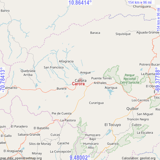
Carora GPS coordinates[2]
10° 10' 22.188" North, 70° 4' 51.6" West
| Map corner | latitude | longitude |
|---|---|---|
| Upper-left | 10.86414°, | -70.78413° |
| Center: | 10.17283°, | -70.081° |
| Lower-right: | 9.48002°, | -69.37788° |
| Map W x H: | 153.9×153.9 km | = 95.6×95.6mi |
| max Lat: | 11.94788° ⇑34.6% North |
| Carora: | 10.17283° |
| min Lat: | ⇓65.4% South 1.92027° |
| min Long | Carora | max Long |
| -72.55212° | -70.081° | -60.99778° |
| W 34.1%⇐ | ⇒65.9% E |
Elevation
Elevation of Carora is 539 m = 1768 ft, and this is 158.4 m = 520 ft above average elevation for this country.
| Max E: |
2986 m = 9797 ft | 24.4% |
| Carora | 539 m 1768 ft | |
| Avg. | 380.6 m = 1249 ft | |
Min E: |
-4 m = -13 ft | 75.6% |
See also: Carora elevation on elevation.city.
Geographical zone
Carora is located in North Torrid zone (between Equator and Tropic of Cancer). Distance of Equator is 1131.1 km =702.8 mi to South.| Distance of | km | miles | from Carora |
|---|---|---|---|
| North Pole | 8875.9 | 5515.2 | to North |
| Arctic Circle | 6270.1 | 3896.1 | to North |
| Tropic Cancer | 1474.8 | 916.4 | to North |
| Equator | 1131.1 | 702.8 | to South |


Nearby cities:
15 places around Carora: (largest is in red/bold)
• Barquisimeto
80.2 km =49.8 mi,  98°
98°
• Biscucuy
91 km =56.5 mi,  173°
173°
• Cabudare
91.1 km =56.6 mi, 100°
• Campo Elías
86.6 km =53.8 mi,  178°
178°
• Carache
62.6 km =38.9 mi,  194°
194°
• Chejendé
68.6 km =42.6 mi,  206°
206°
• Churuguara
92.7 km =57.6 mi,  39°
39°
• El Paradero
73.5 km =45.7 mi,  232°
232°
• El Tocuyo
53.2 km =33.1 mi,  143°
143°
• Los Rastrojos
93.3 km =58 mi, 100°
• Pampán
91.7 km =57 mi, 208°
• Paraíso de Chabasquén
83.5 km =51.9 mi, 169°
• Quíbor
57.3 km =35.6 mi,  118°
118°
• Sanare
66.3 km =41.2 mi,  134°
134°
• Siquisique
60.7 km =37.7 mi, 43°
Sources, notices
• [Note1] Compared only with cities in Venezuela existing in our database
• [Src1] Map data: © OpenStreetMap contributors (CC-BY-SA)
• [Src2] Other city data from geonames.org with taken over terms of usage.
• [Src3] Geographical zone / Annual Mean Temperature by Robert A. Rohde @ Wikipedia
