Ospino geodata
Ospino (Portuguesa) is a seat of a second-order administrative division; located in Venezuela in America/Caracas (GMT-4) time zone. In our database, there are 108 cities with bigger population. Compared to other cities in Venezuela, 58.3% of cities are located further ↑North; 58% of cities are located further →East and 50.6% of cities have lower elevation than Ospino. Note1


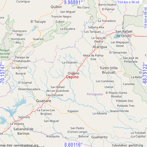
Ospino GPS coordinates[2]
9° 17' 44.592" North, 69° 27' 15.624" West
| Map corner | latitude | longitude |
|---|---|---|
| Upper-left | 9.98891°, | -70.15747° |
| Center: | 9.29572°, | -69.45434° |
| Lower-right: | 8.60116°, | -68.75122° |
| Map W x H: | 154.3×154.3 km | = 95.9×95.9mi |
| max Lat: | 11.94788° ⇑58.3% North |
| Ospino: | 9.29572° |
| min Lat: | ⇓41.7% South 1.92027° |
| min Long | Ospino | max Long |
| -72.55212° | -69.45434° | -60.99778° |
| W 42%⇐ | ⇒58% E |
Elevation
Elevation of Ospino is 184 m = 604 ft, and this is 196.6 m = 645 ft below average elevation for this country.
| Max E: |
2986 m = 9797 ft | 49.4% |
| Avg. | 380.6 m = 1249 ft | |
| Ospino | 184 m = 604 ft | |
Min E: |
-4 m = -13 ft | 50.6% |
See also: Venezuela elevation on elevation.city.
Geographical zone
Ospino is located in North Torrid zone (between Equator and Tropic of Cancer). Distance of Equator is 1033.6 km =642.2 mi to South.| Distance of | km | miles | from Ospino |
|---|---|---|---|
| North Pole | 8973.5 | 5575.9 | to North |
| Arctic Circle | 6367.6 | 3956.6 | to North |
| Tropic Cancer | 1572.3 | 977 | to North |
| Equator | 1033.6 | 642.2 | to South |


Nearby cities:
15 places around Ospino: (largest is in red/bold)
• Acarigua
40.4 km =25.1 mi,  44°
44°
• Agua Blanca
55.8 km =34.7 mi, 43°
• Araure
39.6 km =24.6 mi, 36°
• Biscucuy
58.4 km =36.3 mi,  277°
277°
• Campo Elías
67.2 km =41.8 mi, 279°
• El Playón
49.8 km =30.9 mi,  115°
115°
• El Tocuyo
66.1 km =41.1 mi,  325°
325°
• Guanare
42.4 km =26.3 mi,  228°
228°
• Papelón
39.4 km =24.5 mi,  180°
180°
• Paraíso de Chabasquén
56.2 km =34.9 mi,  285°
285°
• Píritu
28 km =17.4 mi,  72°
72°
• San Rafael de Onoto
67.8 km =42.1 mi,  51°
51°
• Sanare
55.2 km =34.3 mi,  336°
336°
• Sarare
62.7 km =39 mi,  30°
30°
• Villa Bruzual
36.9 km =22.9 mi,  83°
83°
Sources, notices
• [Note1] Compared only with cities in Venezuela existing in our database
• [Src1] Map data: © OpenStreetMap contributors (CC-BY-SA)
• [Src2] Other city data from geonames.org with taken over terms of usage.
• [Src3] Geographical zone / Annual Mean Temperature by Robert A. Rohde @ Wikipedia
