Villa Bruzual geodata
Villa Bruzual (Portuguesa) is a seat of a second-order administrative division; located in Venezuela in America/Caracas (GMT-4) time zone. With population of 27,993 people, there are 102 cities with bigger population in this country. Compared to other cities in Venezuela, 56.7% of cities are located further ↑North; 52.9% of cities are located further →East and 61.8% of cities have higher elevation than Villa Bruzual. Note1


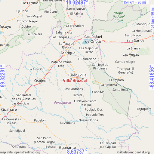
Villa Bruzual GPS coordinates[2]
9° 19' 54.696" North, 69° 7' 10.848" West
| Map corner | latitude | longitude |
|---|---|---|
| Upper-left | 10.02497°, | -69.82281° |
| Center: | 9.33186°, | -69.11968° |
| Lower-right: | 8.63737°, | -68.41656° |
| Map W x H: | 154.3×154.3 km | = 95.9×95.9mi |
| max Lat: | 11.94788° ⇑56.7% North |
| Villa Bruzual: | 9.33186° |
| min Lat: | ⇓43.3% South 1.92027° |
| min Long | Villa Bruzual | max Long |
| -72.55212° | -69.11968° | -60.99778° |
| W 47.1%⇐ | ⇒52.9% E |
Elevation
Elevation of Villa Bruzual is 122 m = 400 ft, and this is 258.6 m = 848 ft below average elevation for this country.
| Max E: |
2986 m = 9797 ft | 61.8% |
| Avg. | 380.6 m = 1249 ft | |
| Villa Bruzual | 122 m = 400 ft | |
Min E: |
-4 m = -13 ft | 38.2% |
See also: Venezuela elevation on elevation.city.
Geographical zone
Villa Bruzual is located in North Torrid zone (between Equator and Tropic of Cancer). Distance of Equator is 1037.6 km =644.7 mi to South.| Distance of | km | miles | from Villa Bruzual |
|---|---|---|---|
| North Pole | 8969.5 | 5573.4 | to North |
| Arctic Circle | 6363.6 | 3954.2 | to North |
| Tropic Cancer | 1568.3 | 974.5 | to North |
| Equator | 1037.6 | 644.7 | to South |


Nearby cities:
15 places around Villa Bruzual: (largest is in red/bold)
• Acarigua
26.1 km =16.2 mi,  341°
341°
• Agua Blanca
36.7 km =22.8 mi,  2°
2°
• Araure
30.7 km =19.1 mi,  334°
334°
• Cojedes
39.1 km =24.3 mi,  34°
34°
• El Playón
27 km =16.8 mi,  162°
162°
• Guanarito
71.3 km =44.3 mi,  187°
187°
• Las Vegas
58.3 km =36.2 mi,  66°
66°
• Libertad
47 km =29.2 mi,  86°
86°
• Ospino
36.9 km =22.9 mi,  263°
263°
• Papelón
57.3 km =35.6 mi,  220°
220°
• Píritu
10.8 km =6.7 mi,  293°
293°
• San Carlos
69.3 km =43.1 mi,  58°
58°
• San Rafael de Onoto
41.7 km =25.9 mi,  22°
22°
• Sanare
74.8 km =46.5 mi,  308°
308°
• Sarare
50.2 km =31.2 mi,  354°
354°
Sources, notices
• [Note1] Compared only with cities in Venezuela existing in our database
• [Src1] Map data: © OpenStreetMap contributors (CC-BY-SA)
• [Src2] Other city data from geonames.org with taken over terms of usage.
• [Src3] Geographical zone / Annual Mean Temperature by Robert A. Rohde @ Wikipedia
