Cabudare geodata
Cabudare (Lara) is a seat of a second-order administrative division; located in Venezuela in America/Caracas (GMT-4) time zone. In our database, there are 108 cities with bigger population. Compared to other cities in Venezuela, 59% of cities are located further ↓South; 56% of cities are located further →East and 73.8% of cities have lower elevation than Cabudare. Note1


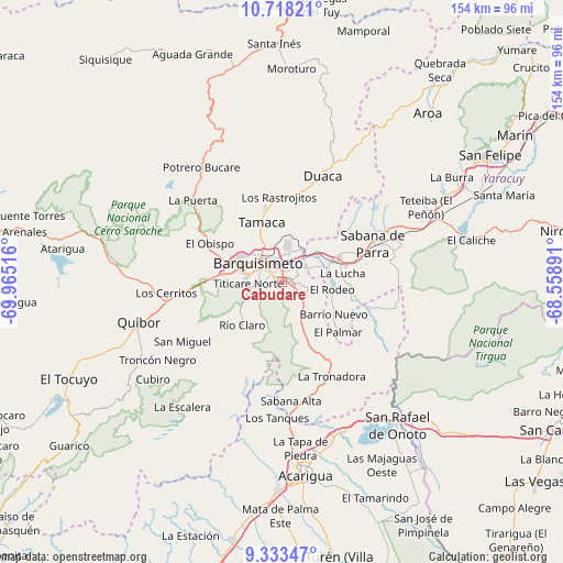
Cabudare GPS coordinates[2]
10° 1' 35.688" North, 69° 15' 43.308" West
| Map corner | latitude | longitude |
|---|---|---|
| Upper-left | 10.71821°, | -69.96516° |
| Center: | 10.02658°, | -69.26203° |
| Lower-right: | 9.33347°, | -68.55891° |
| Map W x H: | 154×154 km | = 95.7×95.7mi |
| max Lat: | 11.94788° ⇑41% North |
| Cabudare: | 10.02658° |
| min Lat: | ⇓59% South 1.92027° |
| min Long | Cabudare | max Long |
| -72.55212° | -69.26203° | -60.99778° |
| W 44%⇐ | ⇒56% E |
Elevation
Elevation of Cabudare is 505 m = 1657 ft, and this is 124.4 m = 408 ft above average elevation for this country.
| Max E: |
2986 m = 9797 ft | 26.2% |
| Cabudare | 505 m 1657 ft | |
| Avg. | 380.6 m = 1249 ft | |
Min E: |
-4 m = -13 ft | 73.8% |
See also: Venezuela elevation on elevation.city.
Geographical zone
Cabudare is located in North Torrid zone (between Equator and Tropic of Cancer). Distance of Equator is 1114.9 km =692.8 mi to South.| Distance of | km | miles | from Cabudare |
|---|---|---|---|
| North Pole | 8892.2 | 5525.4 | to North |
| Arctic Circle | 6286.3 | 3906.1 | to North |
| Tropic Cancer | 1491.1 | 926.5 | to North |
| Equator | 1114.9 | 692.8 | to South |


Nearby cities:
15 places around Cabudare: (largest is in red/bold)
• Acarigua
53 km =32.9 mi,  172°
172°
• Agua Blanca
44 km =27.3 mi,  157°
157°
• Araure
49.6 km =30.8 mi,  177°
177°
• Barquisimeto
11.2 km =7 mi,  292°
292°
• Chivacoa
42.9 km =26.7 mi,  69°
69°
• Duaca
30.8 km =19.1 mi,  20°
20°
• Los Rastrojos
2.2 km =1.4 mi,  91°
91°
• Quíbor
40.7 km =25.3 mi,  254°
254°
• Sabana de Parra
26.8 km =16.7 mi, 66°
• San Pablo
52 km =32.3 mi,  61°
61°
• San Rafael de Onoto
50.1 km =31.1 mi,  140°
140°
• Sanare
52.5 km =32.6 mi,  234°
234°
• Sarare
29.3 km =18.2 mi, 158°
• Urachiche
31.5 km =19.6 mi, 62°
• Yaritagua
16.3 km =10.1 mi, 68°
Sources, notices
• [Note1] Compared only with cities in Venezuela existing in our database
• [Src1] Map data: © OpenStreetMap contributors (CC-BY-SA)
• [Src2] Other city data from geonames.org with taken over terms of usage.
• [Src3] Geographical zone / Annual Mean Temperature by Robert A. Rohde @ Wikipedia
