Quíbor geodata
Quíbor (Lara) is a seat of a second-order administrative division; located in Venezuela in America/Caracas (GMT-4) time zone. With population of 41,526 people, there are 82 cities with bigger population in this country. Compared to other cities in Venezuela, 56.7% of cities are located further ↓South; 59.8% of cities are located further →East and 81.2% of cities have lower elevation than Quíbor. Note1


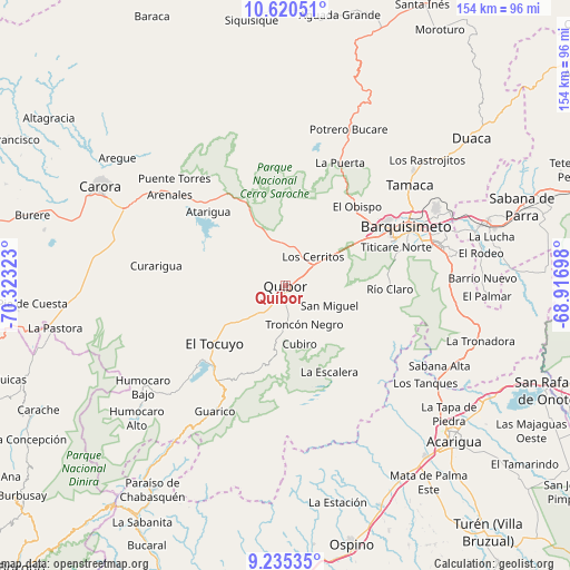
Quíbor GPS coordinates[2]
9° 55' 43.176" North, 69° 37' 12.36" West
| Map corner | latitude | longitude |
|---|---|---|
| Upper-left | 10.62051°, | -70.32323° |
| Center: | 9.92866°, | -69.6201° |
| Lower-right: | 9.23535°, | -68.91698° |
| Map W x H: | 154×154 km | = 95.7×95.7mi |
| max Lat: | 11.94788° ⇑43.3% North |
| Quíbor: | 9.92866° |
| min Lat: | ⇓56.7% South 1.92027° |
| min Long | Quíbor | max Long |
| -72.55212° | -69.6201° | -60.99778° |
| W 40.2%⇐ | ⇒59.8% E |
Elevation
Elevation of Quíbor is 695 m = 2280 ft, and this is 314.4 m = 1031 ft above average elevation for this country.
| Max E: |
2986 m = 9797 ft | 18.8% |
| Quíbor | 695 m 2280 ft | |
| Avg. | 380.6 m = 1249 ft | |
Min E: |
-4 m = -13 ft | 81.2% |
See also: Quíbor elevation on elevation.city.
Geographical zone
Quíbor is located in North Torrid zone (between Equator and Tropic of Cancer). Distance of Equator is 1104 km =686 mi to South.| Distance of | km | miles | from Quíbor |
|---|---|---|---|
| North Pole | 8903.1 | 5532.1 | to North |
| Arctic Circle | 6297.2 | 3912.9 | to North |
| Tropic Cancer | 1502 | 933.3 | to North |
| Equator | 1104 | 686 | to South |


Nearby cities:
15 places around Quíbor: (largest is in red/bold)
• Acarigua
62.4 km =38.8 mi,  131°
131°
• Agua Blanca
63.6 km =39.5 mi,  117°
117°
• Araure
56.9 km =35.4 mi, 132°
• Barquisimeto
32.5 km =20.2 mi,  62°
62°
• Cabudare
40.7 km =25.3 mi,  74°
74°
• Carora
57.3 km =35.6 mi,  298°
298°
• Duaca
63.9 km =39.7 mi,  51°
51°
• El Tocuyo
24.6 km =15.3 mi,  230°
230°
• Los Rastrojos
42.8 km =26.6 mi,  75°
75°
• Paraíso de Chabasquén
65.7 km =40.8 mi,  213°
213°
• Sabana de Parra
67.4 km =41.9 mi, 71°
• Sanare
19.9 km =12.4 mi,  190°
190°
• Sarare
52.7 km =32.7 mi,  108°
108°
• Urachiche
71.7 km =44.6 mi, 69°
• Yaritagua
56.9 km =35.4 mi, 72°
Sources, notices
• [Note1] Compared only with cities in Venezuela existing in our database
• [Src1] Map data: © OpenStreetMap contributors (CC-BY-SA)
• [Src2] Other city data from geonames.org with taken over terms of usage.
• [Src3] Geographical zone / Annual Mean Temperature by Robert A. Rohde @ Wikipedia
