Sarare geodata
Sarare (Lara) is a seat of a second-order administrative division; located in Venezuela in America/Caracas (GMT-4) time zone. In our database, there are 108 cities with bigger population. Compared to other cities in Venezuela, 53.9% of cities are located further ↓South; 53.9% of cities are located further →East and 61.1% of cities have lower elevation than Sarare. Note1


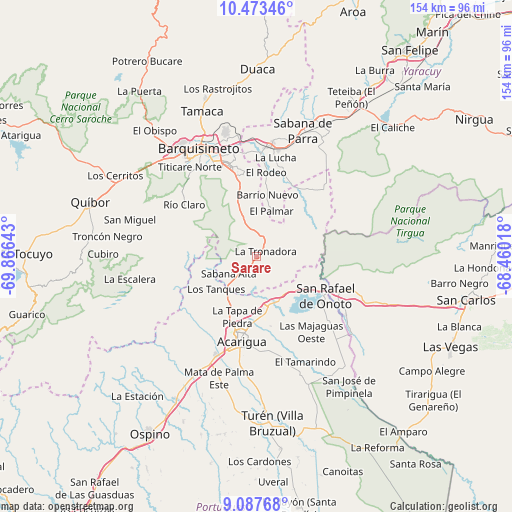
Sarare GPS coordinates[2]
9° 46' 52.644" North, 69° 9' 47.88" West
| Map corner | latitude | longitude |
|---|---|---|
| Upper-left | 10.47346°, | -69.86643° |
| Center: | 9.78129°, | -69.1633° |
| Lower-right: | 9.08768°, | -68.46018° |
| Map W x H: | 154.1×154.1 km | = 95.8×95.8mi |
| max Lat: | 11.94788° ⇑46.1% North |
| Sarare: | 9.78129° |
| min Lat: | ⇓53.9% South 1.92027° |
| min Long | Sarare | max Long |
| -72.55212° | -69.1633° | -60.99778° |
| W 46.1%⇐ | ⇒53.9% E |
Elevation
Elevation of Sarare is 269 m = 883 ft, and this is 111.6 m = 366 ft below average elevation for this country.
| Max E: |
2986 m = 9797 ft | 38.9% |
| Avg. | 380.6 m = 1249 ft | |
| Sarare | 269 m = 883 ft | |
Min E: |
-4 m = -13 ft | 61.1% |
See also: Venezuela elevation on elevation.city.
Geographical zone
Sarare is located in North Torrid zone (between Equator and Tropic of Cancer). Distance of Equator is 1087.6 km =675.8 mi to South.| Distance of | km | miles | from Sarare |
|---|---|---|---|
| North Pole | 8919.5 | 5542.3 | to North |
| Arctic Circle | 6313.6 | 3923.1 | to North |
| Tropic Cancer | 1518.3 | 943.4 | to North |
| Equator | 1087.6 | 675.8 | to South |


Nearby cities:
15 places around Sarare: (largest is in red/bold)
• Acarigua
25.5 km =15.8 mi,  188°
188°
• Agua Blanca
14.6 km =9.1 mi,  154°
154°
• Araure
23.7 km =14.7 mi,  200°
200°
• Barquisimeto
38 km =23.6 mi,  326°
326°
• Cabudare
29.3 km =18.2 mi,  338°
338°
• Chivacoa
51.3 km =31.9 mi,  34°
34°
• Cojedes
32.2 km =20 mi,  123°
123°
• Los Rastrojos
28.5 km =17.7 mi, 342°
• Píritu
45.9 km =28.5 mi, 186°
• Quíbor
52.7 km =32.7 mi,  288°
288°
• Sabana de Parra
40.3 km =25 mi,  20°
20°
• San Rafael de Onoto
23.8 km =14.8 mi, 118°
• Urachiche
45.3 km =28.1 mi, 22°
• Villa Bruzual
50.2 km =31.2 mi,  174°
174°
• Yaritagua
33.6 km =20.9 mi,  7°
7°
Sources, notices
• [Note1] Compared only with cities in Venezuela existing in our database
• [Src1] Map data: © OpenStreetMap contributors (CC-BY-SA)
• [Src2] Other city data from geonames.org with taken over terms of usage.
• [Src3] Geographical zone / Annual Mean Temperature by Robert A. Rohde @ Wikipedia
