Barquisimeto geodata
Barquisimeto (Lara) is a seat of a first-order administrative division; located in Venezuela in America/Caracas (GMT-4) time zone. With population of 809,490 people, there are 4 cities with bigger population in this country. Compared to other cities in Venezuela, 60.3% of cities are located further ↓South; 57.5% of cities are located further →East and 78.6% of cities have lower elevation than Barquisimeto. Note1


Barquisimeto GPS coordinates[2]
10° 3' 52.92" North, 69° 21' 25.308" West
| Map corner | latitude | longitude |
|---|---|---|
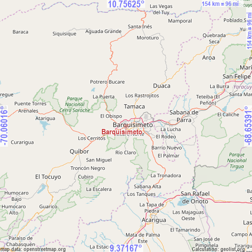
| Upper-left | 10.75625°, | -70.06016° |
| Center: | 10.0647°, | -69.35703° |
| Lower-right: | 9.37167°, | -68.65391° |
| Map W x H: | 154×154 km | = 95.7×95.7mi |
| max Lat: | 11.94788° ⇑39.7% North |
| Barquisimeto: | 10.0647° |
| min Lat: | ⇓60.3% South 1.92027° |
| min Long | Barquisimeto | max Long |
| -72.55212° | -69.35703° | -60.99778° |
| W 42.5%⇐ | ⇒57.5% E |
Elevation
Elevation of Barquisimeto is 606 m = 1988 ft, and this is 225.4 m = 740 ft above average elevation for this country.
| Max E: |
2986 m = 9797 ft | 21.4% |
| Barquisimeto | 606 m 1988 ft | |
| Avg. | 380.6 m = 1249 ft | |
Min E: |
-4 m = -13 ft | 78.6% |
See also: Barquisimeto elevation on elevation.city.
Geographical zone
Barquisimeto is located in North Torrid zone (between Equator and Tropic of Cancer). Distance of Equator is 1119.1 km =695.4 mi to South.| Distance of | km | miles | from Barquisimeto |
|---|---|---|---|
| North Pole | 8888 | 5522.7 | to North |
| Arctic Circle | 6282.1 | 3903.5 | to North |
| Tropic Cancer | 1486.8 | 923.9 | to North |
| Equator | 1119.1 | 695.4 | to South |


Nearby cities:
15 places around Barquisimeto: (largest is in red/bold)
• Acarigua
59.4 km =36.9 mi,  162°
162°
• Agua Blanca
52.5 km =32.6 mi,  148°
148°
• Araure
55.3 km =34.4 mi,  166°
166°
• Cabudare
11.2 km =7 mi,  112°
112°
• Chivacoa
51.7 km =32.1 mi,  78°
78°
• Duaca
32.5 km =20.2 mi,  40°
40°
• El Tocuyo
56.9 km =35.4 mi,  237°
237°
• Los Rastrojos
13.3 km =8.3 mi, 108°
• Quíbor
32.5 km =20.2 mi, 242°
• Sabana de Parra
35.7 km =22.2 mi, 79°
• San Pablo
59.8 km =37.2 mi,  69°
69°
• Sanare
47.5 km =29.5 mi,  222°
222°
• Sarare
38 km =23.6 mi, 146°
• Urachiche
39.6 km =24.6 mi, 74°
• Yaritagua
25.6 km =15.9 mi,  85°
85°
Sources, notices
• [Note1] Compared only with cities in Venezuela existing in our database
• [Src1] Map data: © OpenStreetMap contributors (CC-BY-SA)
• [Src2] Other city data from geonames.org with taken over terms of usage.
• [Src3] Geographical zone / Annual Mean Temperature by Robert A. Rohde @ Wikipedia
