Agua Blanca geodata
Agua Blanca (Portuguesa) is a seat of a second-order administrative division; located in Venezuela in America/Caracas (GMT-4) time zone. In our database, there are 108 cities with bigger population. Compared to other cities in Venezuela, 51.9% of cities are located further ↓South; 52.7% of cities are located further →East and 56.7% of cities have lower elevation than Agua Blanca. Note1


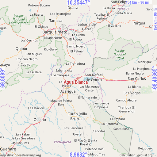
Agua Blanca GPS coordinates[2]
9° 39' 43.38" North, 69° 6' 24.372" West
| Map corner | latitude | longitude |
|---|---|---|
| Upper-left | 10.35447°, | -69.8099° |
| Center: | 9.66205°, | -69.10677° |
| Lower-right: | 8.9682°, | -68.40365° |
| Map W x H: | 154.1×154.1 km | = 95.8×95.8mi |
| max Lat: | 11.94788° ⇑48.1% North |
| Agua Blanca: | 9.66205° |
| min Lat: | ⇓51.9% South 1.92027° |
| min Long | Agua Blanca | max Long |
| -72.55212° | -69.10677° | -60.99778° |
| W 47.3%⇐ | ⇒52.7% E |
Elevation
Elevation of Agua Blanca is 218 m = 715 ft, and this is 162.6 m = 533 ft below average elevation for this country.
| Max E: |
2986 m = 9797 ft | 43.3% |
| Avg. | 380.6 m = 1249 ft | |
| Agua Blanca | 218 m = 715 ft | |
Min E: |
-4 m = -13 ft | 56.7% |
See also: Venezuela elevation on elevation.city.
Geographical zone
Agua Blanca is located in North Torrid zone (between Equator and Tropic of Cancer). Distance of Equator is 1074.3 km =667.5 mi to South.| Distance of | km | miles | from Agua Blanca |
|---|---|---|---|
| North Pole | 8932.7 | 5550.5 | to North |
| Arctic Circle | 6326.9 | 3931.4 | to North |
| Tropic Cancer | 1531.6 | 951.7 | to North |
| Equator | 1074.3 | 667.5 | to South |


Nearby cities:
15 places around Agua Blanca: (largest is in red/bold)
• Acarigua
15.4 km =9.6 mi,  219°
219°
• Araure
17 km =10.6 mi,  238°
238°
• Barquisimeto
52.5 km =32.6 mi,  328°
328°
• Cabudare
44 km =27.3 mi,  337°
337°
• Cojedes
21.2 km =13.2 mi,  102°
102°
• Las Vegas
54.1 km =33.6 mi, 104°
• Los Rastrojos
43.1 km =26.8 mi, 339°
• Ospino
55.8 km =34.7 mi, 223°
• Píritu
34.3 km =21.3 mi,  199°
199°
• Sabana de Parra
51.6 km =32.1 mi,  8°
8°
• San Rafael de Onoto
14.8 km =9.2 mi,  83°
83°
• Sarare
14.6 km =9.1 mi, 334°
• Urachiche
56.3 km =35 mi, 11°
• Villa Bruzual
36.7 km =22.8 mi,  182°
182°
• Yaritagua
46.6 km =29 mi,  357°
357°
Sources, notices
• [Note1] Compared only with cities in Venezuela existing in our database
• [Src1] Map data: © OpenStreetMap contributors (CC-BY-SA)
• [Src2] Other city data from geonames.org with taken over terms of usage.
• [Src3] Geographical zone / Annual Mean Temperature by Robert A. Rohde @ Wikipedia
