El Tocuyo geodata
El Tocuyo (Lara) is a seat of a second-order administrative division; located in Venezuela in America/Caracas (GMT-4) time zone. With population of 53,099 people, there are 71 cities with bigger population in this country. Compared to other cities in Venezuela, 54.2% of cities are located further ↓South; 62.6% of cities are located further →East and 79.1% of cities have lower elevation than El Tocuyo. Note1


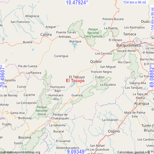
El Tocuyo GPS coordinates[2]
9° 47' 13.524" North, 69° 47' 34.584" West
| Map corner | latitude | longitude |
|---|---|---|
| Upper-left | 10.47924°, | -70.49607° |
| Center: | 9.78709°, | -69.79294° |
| Lower-right: | 9.09349°, | -69.08982° |
| Map W x H: | 154.1×154.1 km | = 95.8×95.8mi |
| max Lat: | 11.94788° ⇑45.8% North |
| El Tocuyo: | 9.78709° |
| min Lat: | ⇓54.2% South 1.92027° |
| min Long | El Tocuyo | max Long |
| -72.55212° | -69.79294° | -60.99778° |
| W 37.4%⇐ | ⇒62.6% E |
Elevation
Elevation of El Tocuyo is 616 m = 2021 ft, and this is 235.4 m = 772 ft above average elevation for this country.
| Max E: |
2986 m = 9797 ft | 20.9% |
| El Tocuyo | 616 m 2021 ft | |
| Avg. | 380.6 m = 1249 ft | |
Min E: |
-4 m = -13 ft | 79.1% |
See also: El Tocuyo elevation on elevation.city.
Geographical zone
El Tocuyo is located in North Torrid zone (between Equator and Tropic of Cancer). Distance of Equator is 1088.2 km =676.2 mi to South.| Distance of | km | miles | from El Tocuyo |
|---|---|---|---|
| North Pole | 8918.8 | 5541.9 | to North |
| Arctic Circle | 6313 | 3922.7 | to North |
| Tropic Cancer | 1517.7 | 943.1 | to North |
| Equator | 1088.2 | 676.2 | to South |


Nearby cities:
15 places around El Tocuyo: (largest is in red/bold)
• Acarigua
70.4 km =43.7 mi,  111°
111°
• Araure
64.9 km =40.3 mi, 110°
• Barquisimeto
56.9 km =35.4 mi,  57°
57°
• Biscucuy
51.9 km =32.2 mi,  203°
203°
• Cabudare
64 km =39.8 mi,  65°
65°
• Campo Elías
52.5 km =32.6 mi,  213°
213°
• Carache
50.9 km =31.6 mi,  249°
249°
• Carora
53.2 km =33.1 mi,  323°
323°
• Chejendé
64.6 km =40.1 mi, 253°
• Los Rastrojos
66 km =41 mi, 66°
• Ospino
66.1 km =41.1 mi,  145°
145°
• Paraíso de Chabasquén
42.8 km =26.6 mi, 203°
• Quíbor
24.6 km =15.3 mi,  50°
50°
• Sanare
15.9 km =9.9 mi,  104°
104°
• Sarare
69 km =42.9 mi,  90°
90°
Sources, notices
• [Note1] Compared only with cities in Venezuela existing in our database
• [Src1] Map data: © OpenStreetMap contributors (CC-BY-SA)
• [Src2] Other city data from geonames.org with taken over terms of usage.
• [Src3] Geographical zone / Annual Mean Temperature by Robert A. Rohde @ Wikipedia
