Thị Trấn Yên Thế geodata
Thị Trấn Yên Thế (Yên Bái) is a seat of a second-order administrative division; located in Vietnam in Asia/Ho_Chi_Minh (GMT+7) time zone. In our database, there are 94 cities with bigger population. Compared to other cities in Vietnam, 91.4% of cities are located further ↓South; 92.5% of cities are located further →East and 74.9% of cities have lower elevation than Thị Trấn Yên Thế. Note1


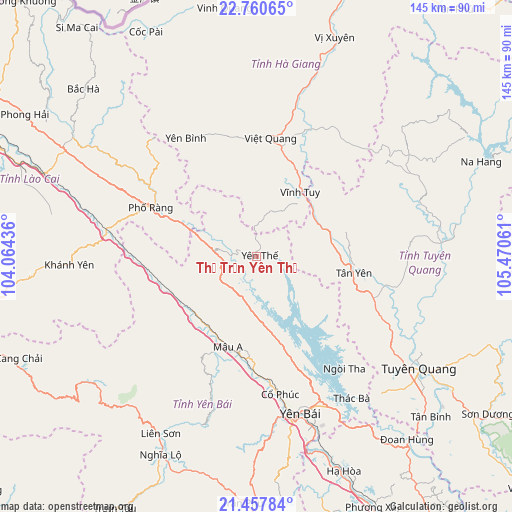
Thị Trấn Yên Thế GPS coordinates[2]
22° 6' 38.7" North, 104° 46' 2.928" East
| Map corner | latitude | longitude |
|---|---|---|
| Upper-left | 22.76065°, | 104.06436° |
| Center: | 22.11075°, | 104.76748° |
| Lower-right: | 21.45784°, | 105.47061° |
| Map W x H: | 144.9×144.9 km | = 90×90mi |
| max Lat: | 23.27841° ⇑8.6% North |
| Thị Trấn Yên Thế: | 22.11075° |
| min Lat: | ⇓91.4% South 8.65724° |
| min Long | Thị Trấn Y� | max Long |
| 102.4579° | 104.76748° | 112.72541° |
| W 7.5%⇐ | ⇒92.5% E |
Elevation
Elevation of Thị Trấn Yên Thế is 96 m = 315 ft, and this is 33.5 m = 110 ft below average elevation for this country.
| Max E: |
1592 m = 5223 ft | 25.1% |
| Avg. | 129.5 m = 425 ft | |
| Thị Trấn Yên Thế | 96 m = 315 ft | |
Min E: |
-1 m = -3 ft | 74.9% |
See also: Vietnam elevation on elevation.city.
Geographical zone
Thị Trấn Yên Thế is located in North Torrid zone (between Equator and Tropic of Cancer). Distance of this Northern Tropic circle is 147.4 km =91.6 mi to North.| Distance of | km | miles | from Thị Trấn Yên Thế |
|---|---|---|---|
| North Pole | 7548.6 | 4690.5 | to North |
| Arctic Circle | 4942.7 | 3071.3 | to North |
| Tropic Cancer | 147.4 | 91.6 | to North |
| Equator | 2458.5 | 1527.6 | to South |


Nearby cities:
15 places around Thị Trấn Yên Thế: (largest is in red/bold)
• Cổ Phúc
39.9 km =24.8 mi,  171°
171°
• Huyện Chiêm Hóa
52.2 km =32.4 mi,  85°
85°
• Sơn Thịnh
63.5 km =39.5 mi,  196°
196°
• Thị Trấn Khánh Yên
53.2 km =33.1 mi,  267°
267°
• Thị Trấn Phố Lu
64.1 km =39.8 mi,  291°
291°
• Thị Trấn Phố Ràng
33 km =20.5 mi, 294°
• Thị Trấn Tân Yên
28 km =17.4 mi,  100°
100°
• Thị Trấn Việt Lâm
60.5 km =37.6 mi,  19°
19°
• Thị Trấn Việt Quang
34.1 km =21.2 mi,  6°
6°
• Thị Trấn Vĩnh Lộc
52.1 km =32.4 mi, 85°
• Thị Trấn Vĩnh Tuy
22.2 km =13.8 mi,  34°
34°
• Thị Trấn Vị Xuyên
65.7 km =40.8 mi, 19°
• Tuyên Quang
56.1 km =34.9 mi,  124°
124°
• Yên Bái
45.6 km =28.3 mi,  161°
161°
• Yên Bình
38.5 km =23.9 mi,  329°
329°
Sources, notices
• [Note1] Compared only with cities in Vietnam existing in our database
• [Src1] Map data: © OpenStreetMap contributors (CC-BY-SA)
• [Src2] Other city data from geonames.org with taken over terms of usage.
• [Src3] Geographical zone / Annual Mean Temperature by Robert A. Rohde @ Wikipedia
