Phú Quý geodata
Phú Quý (Bình Thuận) is a seat of a second-order administrative division; located in Vietnam in Asia/Ho_Chi_Minh (GMT+7) time zone. In our database, there are 94 cities with bigger population. Compared to other cities in Vietnam, 83.5% of cities are located further ↑North; 95.9% of cities are located further ←West and 80.8% of cities have higher elevation than Phú Quý. Note1


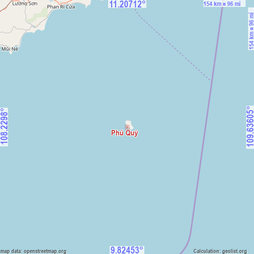
Phú Quý GPS coordinates[2]
10° 30' 59.76" North, 108° 55' 58.512" East
| Map corner | latitude | longitude |
|---|---|---|
| Upper-left | 11.20712°, | 108.2298° |
| Center: | 10.5166°, | 108.93292° |
| Lower-right: | 9.82453°, | 109.63605° |
| Map W x H: | 153.7×153.7 km | = 95.5×95.5mi |
| max Lat: | 23.27841° ⇑83.5% North |
| Phú Quý: | 10.5166° |
| min Lat: | ⇓16.5% South 8.65724° |
| min Long | Phú Quý | max Long |
| 102.4579° | 108.93292° | 112.72541° |
| W 95.9%⇐ | ⇒4.1% E |
Elevation
Elevation of Phú Quý is 6 m = 20 ft, and this is 123.5 m = 405 ft below average elevation for this country.
| Max E: |
1592 m = 5223 ft | 80.8% |
| Avg. | 129.5 m = 425 ft | |
| Phú Quý | 6 m = 20 ft | |
Min E: |
-1 m = -3 ft | 19.2% |
See also: Vietnam elevation on elevation.city.
Geographical zone
Phú Quý is located in North Torrid zone (between Equator and Tropic of Cancer). Distance of Equator is 1169.3 km =726.6 mi to South.| Distance of | km | miles | from Phú Quý |
|---|---|---|---|
| North Pole | 8837.7 | 5491.5 | to North |
| Arctic Circle | 6231.8 | 3872.3 | to North |
| Tropic Cancer | 1436.6 | 892.7 | to North |
| Equator | 1169.3 | 726.6 | to South |


Nearby cities:
15 places around Phú Quý: (largest is in red/bold)
• Bác Ái
147.3 km =91.5 mi,  358°
358°
• Chợ Lầu
91.1 km =56.6 mi,  329°
329°
• Di Linh
150.9 km =93.8 mi,  321°
321°
• Khánh Hải
120 km =74.6 mi,  5°
5°
• La Gi
127.9 km =79.5 mi,  277°
277°
• Liên Hương
82.3 km =51.1 mi,  343°
343°
• Ma Lâm
107.3 km =66.7 mi,  305°
305°
• Phan Rang-Tháp Chàm
116.7 km =72.5 mi,  2°
2°
• Phan Thiết
101.7 km =63.2 mi,  296°
296°
• Phước Dân
112.3 km =69.8 mi, 359°
• Thuận Nam
121 km =75.2 mi,  287°
287°
• Thạnh Mỹ
146.5 km =91 mi, 340°
• Tánh Linh
150.6 km =93.6 mi, 294°
• Tân Sơn
140.9 km =87.6 mi,  353°
353°
• Đưc Trọng
148.7 km =92.4 mi, 335°
Sources, notices
• [Note1] Compared only with cities in Vietnam existing in our database
• [Src1] Map data: © OpenStreetMap contributors (CC-BY-SA)
• [Src2] Other city data from geonames.org with taken over terms of usage.
• [Src3] Geographical zone / Annual Mean Temperature by Robert A. Rohde @ Wikipedia
